
Glenville/Cashiers
Food scene
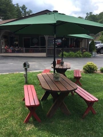
They have great brick oven pizzas, southern style food and lots of delicious daily specials. It's very close to the cottage and has a great outdoor space with a putting green and corn hole to enjoy while taking in the beautiful mountain weather.
21 íbúar mæla með

Happ's Place
5914 State Route 107They have great brick oven pizzas, southern style food and lots of delicious daily specials. It's very close to the cottage and has a great outdoor space with a putting green and corn hole to enjoy while taking in the beautiful mountain weather.
Slab Town Pizza
45 Slab Town RdThe pizza is delicious and they have a nice little outdoor space.
This is a great place to get local fruit, veggies, charcuterie board fixing', a nice bottle of wine, all of which can make great souvenirs to bring home.
53 íbúar mæla með
Cashiers Farmers Market
78 US-64This is a great place to get local fruit, veggies, charcuterie board fixing', a nice bottle of wine, all of which can make great souvenirs to bring home.
Sightseeing
2022 Release Days
To see the big water, visit on these prescribed recreation flow days (West Fork Tuckasegee River Bypass Releases), 10 AM-4 PM: April 2 & 3, June 4, July 16 & 23, August 6 & 20.
Hike Description
From the upper trailhead, the hike begins at the gate on High Falls Trail. You’ll descend on the gravel road for just under 0.2 mile, then turn right on the obvious trail. The trail descends a little over 0.6 mile to the falls. It is well graded and easy to follow but is steep in places and has lots of steps.
From the lower trailhead, take the side road that forks to the right off Shoal Creek Mountain Road. It has an orange gate. You’ll cross Shoal Creek on an auto bridge at 0.1 mile and come to a fork at 0.2 mile. Go left and ascend gradually for 0.4 mile. The trail swings around a ridge, then descends gradually for over 1 mile to a side path on the right. The side path leads to a view of Rough Run Falls. From the side path, it’s another 0.3 mile to High Falls. When you get close to the falls, you’ll have to scramble along the rocks to reach the base.
Most of the lower trail is not on Duke Energy property. The landowners allow public access provided visitors follow these conditions: no four-wheelers or other motorized vehicles, no littering, no camping, no campfires of any kind, no fishing or hunting. In other words, conduct yourself as you would anytime you’re on another person’s property. Break these rules and access for everyone could be denied.
32 íbúar mæla með
High Falls
2022 Release Days
To see the big water, visit on these prescribed recreation flow days (West Fork Tuckasegee River Bypass Releases), 10 AM-4 PM: April 2 & 3, June 4, July 16 & 23, August 6 & 20.
Hike Description
From the upper trailhead, the hike begins at the gate on High Falls Trail. You’ll descend on the gravel road for just under 0.2 mile, then turn right on the obvious trail. The trail descends a little over 0.6 mile to the falls. It is well graded and easy to follow but is steep in places and has lots of steps.
From the lower trailhead, take the side road that forks to the right off Shoal Creek Mountain Road. It has an orange gate. You’ll cross Shoal Creek on an auto bridge at 0.1 mile and come to a fork at 0.2 mile. Go left and ascend gradually for 0.4 mile. The trail swings around a ridge, then descends gradually for over 1 mile to a side path on the right. The side path leads to a view of Rough Run Falls. From the side path, it’s another 0.3 mile to High Falls. When you get close to the falls, you’ll have to scramble along the rocks to reach the base.
Most of the lower trail is not on Duke Energy property. The landowners allow public access provided visitors follow these conditions: no four-wheelers or other motorized vehicles, no littering, no camping, no campfires of any kind, no fishing or hunting. In other words, conduct yourself as you would anytime you’re on another person’s property. Break these rules and access for everyone could be denied.
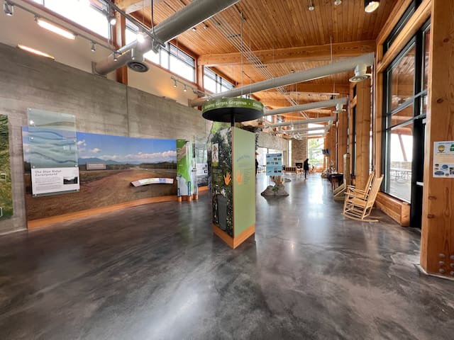
The welcome center is beautiful and includes plenty of interactive stations, nice seating areas, and clean restrooms.
Hiking & Waterfalls
The hike to Rainbow Falls and Turtleback Falls on the Horsepasture River is by far the most popular in the park. The three-mile round-trip hike takes you to the waterfalls located just outside the park in Pisgah National Forest. Also on the river are Hidden Falls and Stairway Falls.
The Bearwallow Valley Trail begins at the top of the picnic area by the information sign. This one-mile round-trip trek takes you to one of the highest overlooks at the park. At 3,200 ft. above sea level, you will enjoy views into South Carolina, including Lake Jocassee and Lake Keowee. Follow red triangle blazes.
107 íbúar mæla með
Gorges ríkisvæði
976 Grassy Ridge RdThe welcome center is beautiful and includes plenty of interactive stations, nice seating areas, and clean restrooms.
Hiking & Waterfalls
The hike to Rainbow Falls and Turtleback Falls on the Horsepasture River is by far the most popular in the park. The three-mile round-trip hike takes you to the waterfalls located just outside the park in Pisgah National Forest. Also on the river are Hidden Falls and Stairway Falls.
The Bearwallow Valley Trail begins at the top of the picnic area by the information sign. This one-mile round-trip trek takes you to one of the highest overlooks at the park. At 3,200 ft. above sea level, you will enjoy views into South Carolina, including Lake Jocassee and Lake Keowee. Follow red triangle blazes.