
Eric’s guidebook for Banff National Park
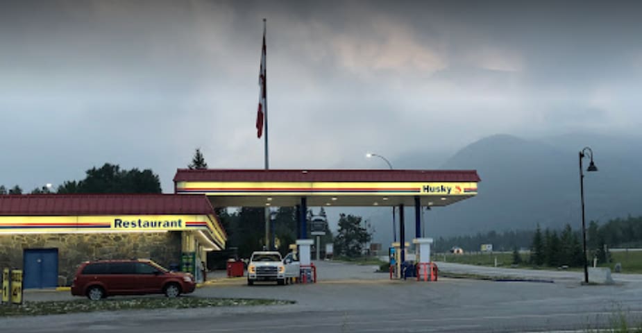
Husky Gas and Convenience Store
This is a good place to fill up your gas tank and purchase snacks. The store employees are very friendly and the gas price here is normally not much higher than Costco in Calgary.
This is a good place to fill up gasoline and purchase small stuff. People in the store are very nice and gas price normally not much higher than the Costco in Calgary
200 1 Ave
200 1 AvenueThis is a good place to fill up gasoline and purchase small stuff. People in the store are very nice and gas price normally not much higher than the Costco in Calgary
Sightseeing
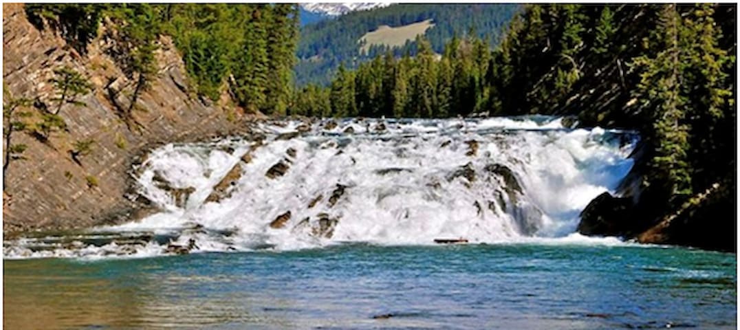
The perfect family hike! The trail winds past a waterfall where it eventually leads you to two majestic turquoise lakes. You can’t miss the panoramic views of Canmore that surround you every step of the hike.
The trail has two routes. The easy route takes you up a gravel access road with a gentle rising slope to the lake. The difficult route takes you through the wooded trail out to the Grassi Lakes Waterfall (pictured above) before a steep accent to the lake. Grassi Lakes is also a popular rock climbing spot.
155 íbúar mæla með
Grassi Lakes
The perfect family hike! The trail winds past a waterfall where it eventually leads you to two majestic turquoise lakes. You can’t miss the panoramic views of Canmore that surround you every step of the hike.
The trail has two routes. The easy route takes you up a gravel access road with a gentle rising slope to the lake. The difficult route takes you through the wooded trail out to the Grassi Lakes Waterfall (pictured above) before a steep accent to the lake. Grassi Lakes is also a popular rock climbing spot.
Lake Minnewanka, 11 kilometers northeast of Banff and half an hour drive from the Copperstone Resort, is the largest lake within the national park and a scenic spot often frequented by bighorn sheep. A popular walking trail leads along the shore and up into the surrounding mountain side. Lake Minnewanka is the only lake in the park on which motorboats are allowed. It is also worthwhile going on to Two Jack Lake – where canoes can be rented – and Johnson Lake
Lake Minnewanka Parking Lot
Lake Minnewanka, 11 kilometers northeast of Banff and half an hour drive from the Copperstone Resort, is the largest lake within the national park and a scenic spot often frequented by bighorn sheep. A popular walking trail leads along the shore and up into the surrounding mountain side. Lake Minnewanka is the only lake in the park on which motorboats are allowed. It is also worthwhile going on to Two Jack Lake – where canoes can be rented – and Johnson Lake
The lake is unique and beautiful. It changes color depending on weather and sunlight. Many hiking trails for all level hikers. The Larch Valley trail is famous for seeing larch trees color changing. A must see!
Moraine Lake in the Valley of the Ten Peaks is arguably as impressive as Lake Louise, but attracts fewer visitors. The picturesque turquoise-colored water is surrounded by ten peaks, each more than 3,000 meters high, and the Wenkchemna Glacier. The lake is located beyond Lake Louise, and the 13-kilometer road leading from Lake Louise up to Moraine Lake reveals one great view after another.
Moraine vatn
The lake is unique and beautiful. It changes color depending on weather and sunlight. Many hiking trails for all level hikers. The Larch Valley trail is famous for seeing larch trees color changing. A must see!
Moraine Lake in the Valley of the Ten Peaks is arguably as impressive as Lake Louise, but attracts fewer visitors. The picturesque turquoise-colored water is surrounded by ten peaks, each more than 3,000 meters high, and the Wenkchemna Glacier. The lake is located beyond Lake Louise, and the 13-kilometer road leading from Lake Louise up to Moraine Lake reveals one great view after another.
you can start with an easy hike with breath taken views!
At 2,068 meters, Bow Pass is the highest pass in Banff National Park and the watershed between the river systems of the North and South Saskatchewan River. A short branch road leads to the magnificent Peyto Lake viewpoint, and there is another superb lookout point that can be reached on foot about a kilometer from the parking area. Peyto Lake is the unique turquoise color of many of the glacier-fed lakes in this area, and is especially lovely in mid to late summer, when Bow Summit’s mountain meadows are carpeted with wildflowers.
A long, steep path from Bow Pass leads down for 2.5 kilometers to Peyto Lake, named after the mountain guide Bill Peyto, who began exploring the area in 1894 and took pack horses of supplies north over Bow Summit.
Peyto Lake Upper Viewpoint
you can start with an easy hike with breath taken views!
At 2,068 meters, Bow Pass is the highest pass in Banff National Park and the watershed between the river systems of the North and South Saskatchewan River. A short branch road leads to the magnificent Peyto Lake viewpoint, and there is another superb lookout point that can be reached on foot about a kilometer from the parking area. Peyto Lake is the unique turquoise color of many of the glacier-fed lakes in this area, and is especially lovely in mid to late summer, when Bow Summit’s mountain meadows are carpeted with wildflowers.
A long, steep path from Bow Pass leads down for 2.5 kilometers to Peyto Lake, named after the mountain guide Bill Peyto, who began exploring the area in 1894 and took pack horses of supplies north over Bow Summit.
About 26 kilometers along the Bow Valley Parkway is the entrance to Johnston Canyon with its two waterfalls. A trail leads through the canyon, with bridges along the steep cliff walls allowing visitors to get a feel for being in one of these unique canyons. The path continues on some six kilometers on the far side of the canyon, leading up to the Ink Pots, a group of springs.
Two of these are particularly striking because of the bluish-green color of the water. Most visitors just stick to the lower level, while those with more time and energy take on the more strenuous walk to the Ink Pots. Johnston Canyon is an impressive site in both summer and winter, although it sees very few visitors outside of the summer season.
Johnston Canyon, Lower Falls
About 26 kilometers along the Bow Valley Parkway is the entrance to Johnston Canyon with its two waterfalls. A trail leads through the canyon, with bridges along the steep cliff walls allowing visitors to get a feel for being in one of these unique canyons. The path continues on some six kilometers on the far side of the canyon, leading up to the Ink Pots, a group of springs.
Two of these are particularly striking because of the bluish-green color of the water. Most visitors just stick to the lower level, while those with more time and energy take on the more strenuous walk to the Ink Pots. Johnston Canyon is an impressive site in both summer and winter, although it sees very few visitors outside of the summer season.
The 48-kilometer-long Bow Valley Parkway, which runs between Banff and Lake Louise, offers an alternative route to the busy Trans-Canada Highway. This route has numerous viewpoints as well as camping and picnic sites. Towering above it all is Castle Mountain, whose Eisenhower Peak is 2,728 meters high. The Bow Valley Parkway also offers a great chance to see some of the park’s wildlife. One of the most popular stops along the parkway is Johnston Canyon
Bow Valley Parkway - Lake Louise side
The 48-kilometer-long Bow Valley Parkway, which runs between Banff and Lake Louise, offers an alternative route to the busy Trans-Canada Highway. This route has numerous viewpoints as well as camping and picnic sites. Towering above it all is Castle Mountain, whose Eisenhower Peak is 2,728 meters high. The Bow Valley Parkway also offers a great chance to see some of the park’s wildlife. One of the most popular stops along the parkway is Johnston Canyon
Not like your typical waterfalls, the Bow Falls is wide and short. You might feel some mist from the waterfalls during the mid-summer due to the high water levels. You can also see the valley that was eroded by glacier activity and the Bow river over the years.
Across the bridge from the town turn left onto Spray Avenue, then take a left on Bow Falls drive, you will see parking on the left soon. You may not see the falls from parking lot yet, get closer to the water and you can’t miss it. The waterfalls are to your left and the valley straight ahead of you.
Late afternoon or even evenings will be quietest times to visit here. There is a trail that you can walk on from the town. Basically walk along the south side of the river after the bridge towards the East. There will be a sign.
Bow Falls, Banff, AB T0L, Canada
Not like your typical waterfalls, the Bow Falls is wide and short. You might feel some mist from the waterfalls during the mid-summer due to the high water levels. You can also see the valley that was eroded by glacier activity and the Bow river over the years.
Across the bridge from the town turn left onto Spray Avenue, then take a left on Bow Falls drive, you will see parking on the left soon. You may not see the falls from parking lot yet, get closer to the water and you can’t miss it. The waterfalls are to your left and the valley straight ahead of you.
Late afternoon or even evenings will be quietest times to visit here. There is a trail that you can walk on from the town. Basically walk along the south side of the river after the bridge towards the East. There will be a sign.
The Banff Sightseeing Gondola is located just 5 minutes from the Town of Banff, on the shoulder of Sulphur Mountain, in the heart of the Canadian Rockies.You will feel like you’re on top of the world when you are standing on the spacious main level observation deck, where the optional Banff Skywalk (a 1km self-guided interpretive walkway) leads you to the Cosmic Ray Station National Historic Site and Sanson’s Peak Meteorological Station
86 íbúar mæla með
Banff Gondola
100 Mountain AveThe Banff Sightseeing Gondola is located just 5 minutes from the Town of Banff, on the shoulder of Sulphur Mountain, in the heart of the Canadian Rockies.You will feel like you’re on top of the world when you are standing on the spacious main level observation deck, where the optional Banff Skywalk (a 1km self-guided interpretive walkway) leads you to the Cosmic Ray Station National Historic Site and Sanson’s Peak Meteorological Station
The jewel of Banff National Park is Lake Louise with its shimmering turquoise green water and surrounding snow capped mountains rising up to 3,000 meters high. Although the water is too cold for bathing, it is ideal for canoeing. At the western end of Lake Louise, Mount Victoria (3,469 meters), rises in majestic splendor. A breathtaking view can be had from the shoreline. A paved trail runs along the water’s edge with beautiful views of the lake, mountains, and glacier.
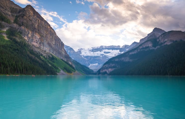
Lake Louise, Improvement District No. 9, AB T0L, Canada
The jewel of Banff National Park is Lake Louise with its shimmering turquoise green water and surrounding snow capped mountains rising up to 3,000 meters high. Although the water is too cold for bathing, it is ideal for canoeing. At the western end of Lake Louise, Mount Victoria (3,469 meters), rises in majestic splendor. A breathtaking view can be had from the shoreline. A paved trail runs along the water’s edge with beautiful views of the lake, mountains, and glacier.
Bow Lake, 34 kilometers north of Lake Louise, lies below the Crowfoot Glacier (shaped like a crow’s foot and clearly visible from the road) and Bow Glacier. The lake’s still and clear waters mirror the towering, snow-covered peaks of the continental divide. These glaciers form part of the great Waputik Icefield. There are lovely walks along the lake to a waterfall at the foot of the Bow Glacier (half a day) or to Helen Lake and Catherine Lake at the Dolomite Pass to the east (whole day).
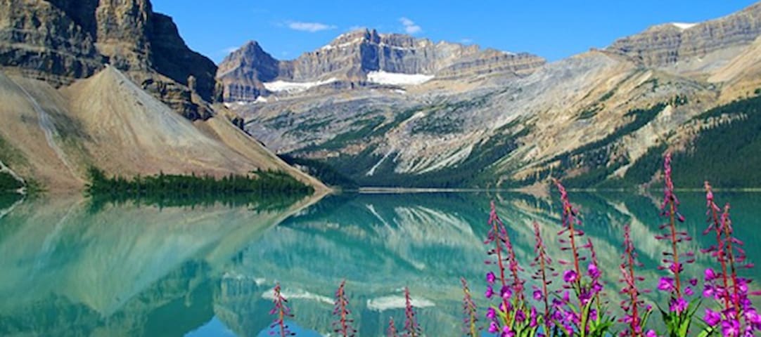
Bow Lake, Improvement District No. 9, AB T0L, Canada
Bow Lake, 34 kilometers north of Lake Louise, lies below the Crowfoot Glacier (shaped like a crow’s foot and clearly visible from the road) and Bow Glacier. The lake’s still and clear waters mirror the towering, snow-covered peaks of the continental divide. These glaciers form part of the great Waputik Icefield. There are lovely walks along the lake to a waterfall at the foot of the Bow Glacier (half a day) or to Helen Lake and Catherine Lake at the Dolomite Pass to the east (whole day).
Ski Resorts
Easier downhill skiing trails and beautiful views
Lake Louise Ski Area
1 Whitehorn RdMore advanced downhill skiing and beautiful views
Nakiska Skíðasvæði
2 Mt Allan DrVery close to Copperstone Resort and less crowed
Canmore Nordic Centre station
Great place for cross country skiing and golfing
Sunshine Village
Great skiing place with beautiful views
City/town information
The world famous small town for hiking and skiing with less accommodate costs. The is surrounded by mountains and many hiking trails.
307 íbúar mæla með
Canmore
The world famous small town for hiking and skiing with less accommodate costs. The is surrounded by mountains and many hiking trails.