
Biking in the Seattle Area
Sightseeing
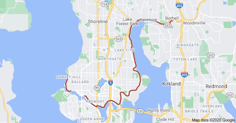
Spanning over 18 miles from Bothell through Seattle’s northern neighborhoods and ending in Ballard, the Burke-Gilman Trail is our go-to north end paved bike path. While this rail-trail route almost always lined with bikers and runners, the phenomenal views of the Ballard Locks, the mountains, Lake Union, and the Seattle skyline make it well worth the crowds. Fitt Tip: you can wave to our favorite Seattle landmark—the Fremont Troll—as you pedal by.
233 íbúar mæla með
Burke Gilman Trail
Burke-Gilman TrailSpanning over 18 miles from Bothell through Seattle’s northern neighborhoods and ending in Ballard, the Burke-Gilman Trail is our go-to north end paved bike path. While this rail-trail route almost always lined with bikers and runners, the phenomenal views of the Ballard Locks, the mountains, Lake Union, and the Seattle skyline make it well worth the crowds. Fitt Tip: you can wave to our favorite Seattle landmark—the Fremont Troll—as you pedal by.
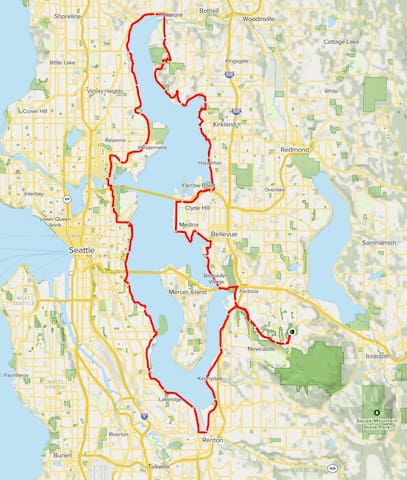
This ride traces a loop around the shoreline of Lake Washington. It follows a mix of trails and city streets, and keeps to mostly residential but still very scenic areas. The route provides plenty of views of the lake along with the surrounding mountains and hills in the distance, and opportunities on both sides to stop and stretch your legs in a number of waterfront parks.
Lake Washington Road Bike Loop is a 63.2 mile moderately trafficked loop trail located near Bellevue, Washington that features a great forest setting and is rated as difficult. The trail is primarily used for road biking.
Lake Washington Loop
Lake Washington LoopThis ride traces a loop around the shoreline of Lake Washington. It follows a mix of trails and city streets, and keeps to mostly residential but still very scenic areas. The route provides plenty of views of the lake along with the surrounding mountains and hills in the distance, and opportunities on both sides to stop and stretch your legs in a number of waterfront parks.
Lake Washington Road Bike Loop is a 63.2 mile moderately trafficked loop trail located near Bellevue, Washington that features a great forest setting and is rated as difficult. The trail is primarily used for road biking.
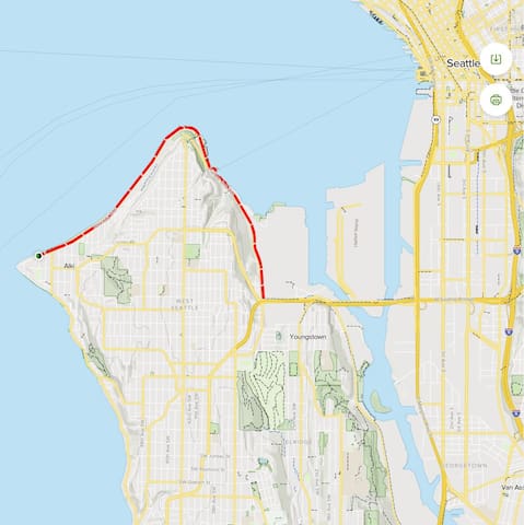
There is a reason so many people flock to Alki Beach at all times of the year: the views are unbeatable. From the east side of the beach, you can take in the entire Seattle skyline, beautifully framed by the Puget Sound and the Cascade Mountains. And from the west side, on a clear day you’ll see the crisp, snow-covered Olympics in all their glory. This trail is undeniably crowded, but with designated bike-only paths, you’ll be able to cut around beach-walkers and rollerbladers with ease.
Alki Trail
Alki TrailThere is a reason so many people flock to Alki Beach at all times of the year: the views are unbeatable. From the east side of the beach, you can take in the entire Seattle skyline, beautifully framed by the Puget Sound and the Cascade Mountains. And from the west side, on a clear day you’ll see the crisp, snow-covered Olympics in all their glory. This trail is undeniably crowded, but with designated bike-only paths, you’ll be able to cut around beach-walkers and rollerbladers with ease.
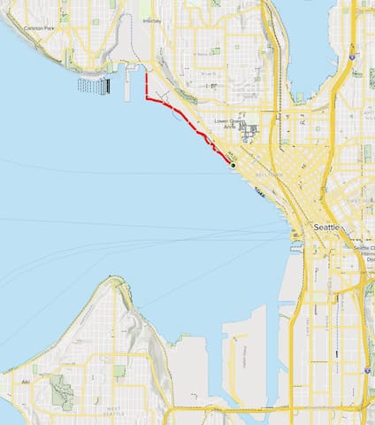
Myrtle Edwards Park to Elliott Bay Park is a 3.5 mile moderately trafficked out and back trail located near Seattle, Washington that offers the chance to see wildlife and is good for all skill levels. The trail offers a number of activity options. Dogs are also able to use this trail but must be kept on leash.
Elliot Bay Trail
Elliot Bay TrailMyrtle Edwards Park to Elliott Bay Park is a 3.5 mile moderately trafficked out and back trail located near Seattle, Washington that offers the chance to see wildlife and is good for all skill levels. The trail offers a number of activity options. Dogs are also able to use this trail but must be kept on leash.
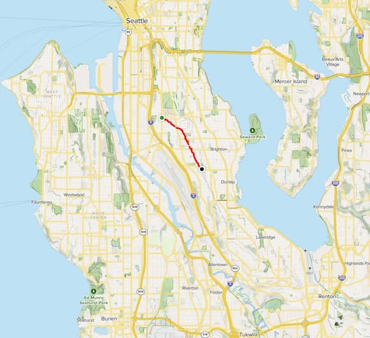
Chief Sealth Trail is a 3.6 mile moderately trafficked point-to-point trail located near Seattle, Washington that offers scenic views and is good for all skill levels. The trail is primarily used for walking and road biking and is accessible year-round. Dogs are also able to use this trail but must be kept on leash.
8 íbúar mæla með
Chief Sealth Trail
Chief Sealth TrailChief Sealth Trail is a 3.6 mile moderately trafficked point-to-point trail located near Seattle, Washington that offers scenic views and is good for all skill levels. The trail is primarily used for walking and road biking and is accessible year-round. Dogs are also able to use this trail but must be kept on leash.
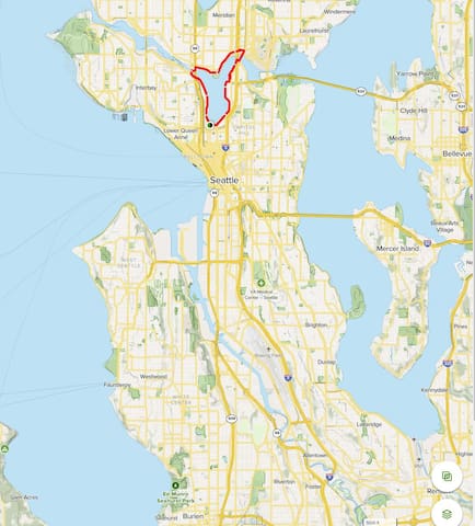
Lake Union Loop is a 6.4 mile heavily trafficked loop trail located near Seattle, Washington that offers scenic views and is good for all skill levels. The trail is primarily used for walking, running, bird watching, and road biking. Dogs are also able to use this trail but must be kept on leash.
Cheshiahud Lake Union Loop
Cheshiahud Lake Union LoopLake Union Loop is a 6.4 mile heavily trafficked loop trail located near Seattle, Washington that offers scenic views and is good for all skill levels. The trail is primarily used for walking, running, bird watching, and road biking. Dogs are also able to use this trail but must be kept on leash.
A great resource for bike rentals in Seattle AND they bring the bike to you
6 íbúar mæla með
Pedal Anywhere Seattle
611 Eastlake Ave EA great resource for bike rentals in Seattle AND they bring the bike to you
An electric bike rental is a great way to experience Seattle and beyond! The nearby bike trails are safe and breathtakingly beautiful.
Visitors always say it’s the most fun and memorable activity of their trip. And locals are surprised to find such an amazing experience right in their own backyard.
Wherever you’re from, we’ll bend over backwards to make sure you leave with a giant smile on your face!
Locks and helmets are included with every rental.
Pedego Electric Bikes Seattle
2609 NW Market StAn electric bike rental is a great way to experience Seattle and beyond! The nearby bike trails are safe and breathtakingly beautiful.
Visitors always say it’s the most fun and memorable activity of their trip. And locals are surprised to find such an amazing experience right in their own backyard.
Wherever you’re from, we’ll bend over backwards to make sure you leave with a giant smile on your face!
Locks and helmets are included with every rental.
Alki Bike & Board
2606 California Ave SWhttp://alkibikeandboard.com/bike-rentals-2020/
Seattle by Bike offers guided bicycle tours that make memories and explore the best sights and
sounds of the Emerald City. Specializing in: bike tours, sightseeing, city tours, outdoor activities,
bike rentals, and guided tours
Seattle by Bike
1007 NE Boat StSeattle by Bike offers guided bicycle tours that make memories and explore the best sights and
sounds of the Emerald City. Specializing in: bike tours, sightseeing, city tours, outdoor activities,
bike rentals, and guided tours
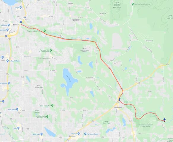
The Cedar River Trail follows the Cedar River from where it enters Lake Washington in the City of Renton upriver to the community of Landsburg at the boundary of the City of Seattle’s Cedar River Watershed. At 17.4 miles in length the CRT is a paved, off-road trail for the first 12.3 miles, and features a soft surface for the last five miles.
The trail follows a historic railroad route between the river and State Route 169, and passes through or near Renton, Maplewood, Cedar Mountain, Maple Valley, and Rock Creek. It offers views and access to Lake Washington, downtown Renton, Cedar River Park, Maplewood Golf Course, Ron Regis Park, Cedar Grove Park, and Maple Valley.
The CRT also provides excellent views and access to the Cedar River along its length. Between Renton and Maple Valley the CRT is popular with bicyclists and skaters and provides both recreational and non-motorized commuting opportunities. At Maple Valley the trail intersects the Green-To-Cedar Rivers Trail, which runs through central Maple Valley, then continues to the more secluded Rock Creek area and onto Landsburg in a wooded river valley. This soft-surface segment is popular with off-road bicyclists, joggers, walkers and equestrians. Parking is provided at both ends of the trail, and at numerous locations along its length.
10 íbúar mæla með
Cedar River Trail Park
901 Nishiwaki LnThe Cedar River Trail follows the Cedar River from where it enters Lake Washington in the City of Renton upriver to the community of Landsburg at the boundary of the City of Seattle’s Cedar River Watershed. At 17.4 miles in length the CRT is a paved, off-road trail for the first 12.3 miles, and features a soft surface for the last five miles.
The trail follows a historic railroad route between the river and State Route 169, and passes through or near Renton, Maplewood, Cedar Mountain, Maple Valley, and Rock Creek. It offers views and access to Lake Washington, downtown Renton, Cedar River Park, Maplewood Golf Course, Ron Regis Park, Cedar Grove Park, and Maple Valley.
The CRT also provides excellent views and access to the Cedar River along its length. Between Renton and Maple Valley the CRT is popular with bicyclists and skaters and provides both recreational and non-motorized commuting opportunities. At Maple Valley the trail intersects the Green-To-Cedar Rivers Trail, which runs through central Maple Valley, then continues to the more secluded Rock Creek area and onto Landsburg in a wooded river valley. This soft-surface segment is popular with off-road bicyclists, joggers, walkers and equestrians. Parking is provided at both ends of the trail, and at numerous locations along its length.
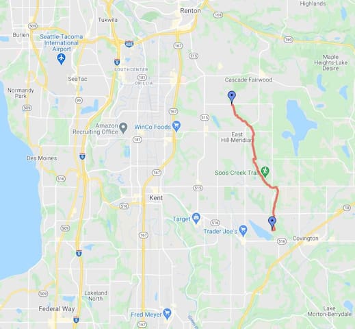
The Soos Creek Trail features a gentle grade in a natural setting suitable for leisurely strolls, bicycle rides and horse rides. A Connection to the Lake Youngs Trail (9 miles, unpaved) can be made along SE 216th St corridor.
Length: 5.9 miles.
Surface - Paved with soft shoulder. A separate soft surface trail for equestrians exists along some portions of the trail.
Use: All non-motorized use.
Soos Creek gönguleið
The Soos Creek Trail features a gentle grade in a natural setting suitable for leisurely strolls, bicycle rides and horse rides. A Connection to the Lake Youngs Trail (9 miles, unpaved) can be made along SE 216th St corridor.
Length: 5.9 miles.
Surface - Paved with soft shoulder. A separate soft surface trail for equestrians exists along some portions of the trail.
Use: All non-motorized use.
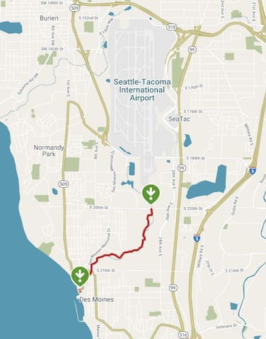
The Des Moines Creek Trail offers a nice connection between the south side of Seattle and the waterfront community of Des Moines on Puget Sound. The paved trail begins just south of the Seattle-Tacoma International Airport and winds through the pleasantly wooded Des Moines Creek Park along a burbling creek down to the city's marina, descending slightly as it approaches the water.
The park offers basic amenities, such as benches, picnic tables, and drinking fountains, as well as a network of mountain biking trails to explore. On the trail's southern end, enjoy a stroll over the water on the long pier. You can also continue your journey south on a shared-road bike route on Marine View Drive about 2 miles to Saltwater State Park, where you'll find sandy beaches, tide pools, and a scuba diving reef.
Parking and Trail Access
Parking is available on the north end of the trail in Des Moines Creek Park (2151 S. 200th Street) and, on the south end of the trail, in Des Moines Beach Park (22030 Cliff Avenue South).
10 íbúar mæla með
Des Moines Creek Trail Park
2151 S 200th StThe Des Moines Creek Trail offers a nice connection between the south side of Seattle and the waterfront community of Des Moines on Puget Sound. The paved trail begins just south of the Seattle-Tacoma International Airport and winds through the pleasantly wooded Des Moines Creek Park along a burbling creek down to the city's marina, descending slightly as it approaches the water.
The park offers basic amenities, such as benches, picnic tables, and drinking fountains, as well as a network of mountain biking trails to explore. On the trail's southern end, enjoy a stroll over the water on the long pier. You can also continue your journey south on a shared-road bike route on Marine View Drive about 2 miles to Saltwater State Park, where you'll find sandy beaches, tide pools, and a scuba diving reef.
Parking and Trail Access
Parking is available on the north end of the trail in Des Moines Creek Park (2151 S. 200th Street) and, on the south end of the trail, in Des Moines Beach Park (22030 Cliff Avenue South).
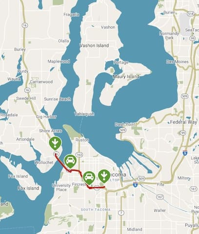
The Scott Pierson Trail runs parallel to State Route 16 for most of its journey from 25th Street in Tacoma to 24th Street on the southern edge of Gig Harbor. The 5-mile trail is a safe and convenient option for bicyclists and pedestrians to cross Puget Sound, although it is often loud due to its close proximity to a busy highway.
The trail is named in honor of the longtime landscape architect and urban planner in Tacoma who advocated tirelessly for its creation. The highlight of the route is undoubtedly the impressive Tacoma Narrows Bridge, which offers sweeping views of Puget Sound as it carries separated vehicular and bike/ped traffic from Tacoma to the Kitsap Peninsula, and vice versa.
In Tacoma, the trail links walkers, runners and cyclists to a variety of amenities, including War Memorial Park, the Tacoma Nature Center at Snake Lake and Cheney Stadium (home of Minor League Baseball's Tacoma Rainiers). Unfortunately, the trail is not always well-marked in Tacoma. Refer to the TrailLink map for the exact route.
Parking and Trail Access
Parking for the Scott Pierson Trail can be found close to the Tacoma Narrows Bridge at the intersection of 6th Avenue and N. Skyline Drive in Tacoma. Farther east, a park and ride lot off Center Street between S. Tyler Street and S. Mullen Street should have parking. A trail spur leads directly from the parking lot under SR 16 to the main trail near Cheney Stadium.
Scott Pierson Trail
Scott Pierson TrailThe Scott Pierson Trail runs parallel to State Route 16 for most of its journey from 25th Street in Tacoma to 24th Street on the southern edge of Gig Harbor. The 5-mile trail is a safe and convenient option for bicyclists and pedestrians to cross Puget Sound, although it is often loud due to its close proximity to a busy highway.
The trail is named in honor of the longtime landscape architect and urban planner in Tacoma who advocated tirelessly for its creation. The highlight of the route is undoubtedly the impressive Tacoma Narrows Bridge, which offers sweeping views of Puget Sound as it carries separated vehicular and bike/ped traffic from Tacoma to the Kitsap Peninsula, and vice versa.
In Tacoma, the trail links walkers, runners and cyclists to a variety of amenities, including War Memorial Park, the Tacoma Nature Center at Snake Lake and Cheney Stadium (home of Minor League Baseball's Tacoma Rainiers). Unfortunately, the trail is not always well-marked in Tacoma. Refer to the TrailLink map for the exact route.
Parking and Trail Access
Parking for the Scott Pierson Trail can be found close to the Tacoma Narrows Bridge at the intersection of 6th Avenue and N. Skyline Drive in Tacoma. Farther east, a park and ride lot off Center Street between S. Tyler Street and S. Mullen Street should have parking. A trail spur leads directly from the parking lot under SR 16 to the main trail near Cheney Stadium.
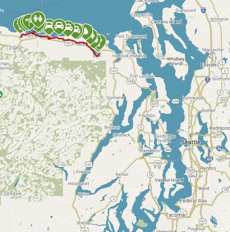
The section of the Olympic Discovery Trail sandwiched between Sequim Bay and the Elwha River is considered the trail system's crown jewel. Bounded by a sparkling tidal estuary in the east and a recently undammed river in the west, the rail-trail visits the towns of Sequim and Port Angeles as it crosses the base of the Olympic Mountains.
The route follows the corridor of the Seattle, Port Angeles & Western Railway, constructed between Port Angeles and Discovery Bay from 1914 to 1915. The railway linked with the Port Townsend & Southern Railroad but didn't connect to a main line. The railroad solved the problem by using barges to transport railroad cars across Puget Sound. The railway had the distinction of being the only one in the nation whose schedule was determined by the tides. By 1931, the railroad had discontinued passenger service, and the Chicago, Milwaukee, St. Paul and Pacific Railroad had acquired the line to haul freight and timber. The Seattle & North Coast Railroad bought the railway in 1981 and reinstituted passenger service between Port Angeles and Port Townsend. It didn't take hold, however, and crews began removing track in 1985. Soon after, the Peninsula Trails Coalition formed to build a trail.
12 íbúar mæla með
Olympic Discovery Trail
Olympic Discovery TrailThe section of the Olympic Discovery Trail sandwiched between Sequim Bay and the Elwha River is considered the trail system's crown jewel. Bounded by a sparkling tidal estuary in the east and a recently undammed river in the west, the rail-trail visits the towns of Sequim and Port Angeles as it crosses the base of the Olympic Mountains.
The route follows the corridor of the Seattle, Port Angeles & Western Railway, constructed between Port Angeles and Discovery Bay from 1914 to 1915. The railway linked with the Port Townsend & Southern Railroad but didn't connect to a main line. The railroad solved the problem by using barges to transport railroad cars across Puget Sound. The railway had the distinction of being the only one in the nation whose schedule was determined by the tides. By 1931, the railroad had discontinued passenger service, and the Chicago, Milwaukee, St. Paul and Pacific Railroad had acquired the line to haul freight and timber. The Seattle & North Coast Railroad bought the railway in 1981 and reinstituted passenger service between Port Angeles and Port Townsend. It didn't take hold, however, and crews began removing track in 1985. Soon after, the Peninsula Trails Coalition formed to build a trail.