
Laurie’s guidebook
Food scene
Lisa G's
6125 Sentinel RdGreat food and drinks in a casual atmosphere! Closed Tuesdays.
Smoke Signals
2489 Main StPopular bbq restaurant on Main Street.
Dack Shack
2099 Saranac AveGreat food available for take out only during COVID.
Simply Gourmet
2099 Saranac AveGreat sandwiches available for take out. Visit them on Facebook!
The Cottage
77 Mirror Lake DrCasual dining on Mirror Lake.
Low-key brewery & tap room offering small plates, pizza & Sunday Brunch, plus 10 rotating beers.
76 íbúar mæla með
Big Slide Brewery & Public House
5686 Cascade RdLow-key brewery & tap room offering small plates, pizza & Sunday Brunch, plus 10 rotating beers.
CAKES PASTRIES COOKIES CHOCOLATE ... At Bluesberry they make every item from scratch, using nothing less than high-quality, all-natural ingredients.
Kare

Bluesberry Bakery
2436 Main StCAKES PASTRIES COOKIES CHOCOLATE ... At Bluesberry they make every item from scratch, using nothing less than high-quality, all-natural ingredients.
Kare
Cones, sundaes, old fashion milkshakes, ice cream cakes — something for everyone can be found at Emma's, where every day's a good day for ice cream!
18 íbúar mæla með

Emma's Lake Placid Creamery
2507 Main StCones, sundaes, old fashion milkshakes, ice cream cakes — something for everyone can be found at Emma's, where every day's a good day for ice cream!
Things to do
Mirror Lake Boat Rental
2403 Main StVariety of SUPS, kayaks, canoes.
High Peaks Cyclery
2733 Main StBike Rentals
Explore the Grand Canyon of the Adirondacks!
Located about 45 minutes from Lake Placid.
www.ausablechasm.com
40 íbúar mæla með
Ausable Chasm
Explore the Grand Canyon of the Adirondacks!
Located about 45 minutes from Lake Placid.
www.ausablechasm.com
Enjoy a Gondola Ride in the summer or downhill skiing in the winter.
www.whiteface.com/
224 íbúar mæla með
Whiteface Mountain
Whiteface Memorial HighwayEnjoy a Gondola Ride in the summer or downhill skiing in the winter.
www.whiteface.com/
Experience Outdoors, LLC
4948 Cascade RdZiplining
www.expoutdoors.com
The Adirondacks' most breathtaking 30 minute walk with hiking trails, waterfalls, river walk, restaurant and gift shop near Lake Placid NY in Wilmington NY.
102 íbúar mæla með
High Falls Gorge
4761 NY-86The Adirondacks' most breathtaking 30 minute walk with hiking trails, waterfalls, river walk, restaurant and gift shop near Lake Placid NY in Wilmington NY.
The Wild Center, formerly known as the Natural History Museum of the Adirondacks, is a natural history center in Tupper Lake, New York, near the center of New York state's Adirondack Park.
176 íbúar mæla með
Villt miðstöð
45 Museum DrThe Wild Center, formerly known as the Natural History Museum of the Adirondacks, is a natural history center in Tupper Lake, New York, near the center of New York state's Adirondack Park.
Sightseeing
Visit the new Gondola, take an elevator ride to the top of the jumps, or try ziplining!
85 íbúar mæla með
Lake Placid Olympic Ski Jumping Complex
5486 Cascade RdVisit the new Gondola, take an elevator ride to the top of the jumps, or try ziplining!
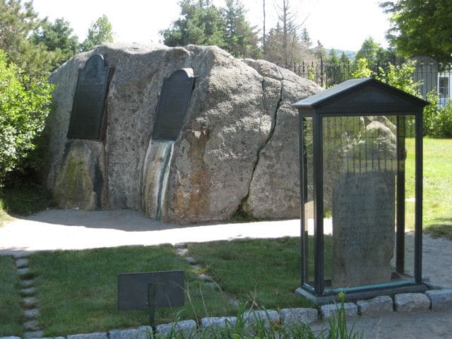
John Brown Farm State Historic Site
115 John Brown RoadTake a Hike in the High Peaks
Easy/Moderate Climbs
1. Mt Jo: Superior Views of the High Peaks and Heart Lake for a short but steep climb. 2.3 miles Round Trip. Elevation 2876’. Suitable for families.
2. Scarface Mountain: Trailhead: .01 mi down Raybrook Rd. from Rt. 86. 6.6 miles RT, Elevation 3088’. This hike leads to an open ledge with great views overlooking Oseetah Lake and the Saranac Lakes Chain. Time in hours: Family with Young Kids: To Summit: 3.0 Round Trip: 5.5
Experienced Hiker: To Summit: 1.75 Round Trip: 4.0
Out of Shape Hiker: To Summit: 2.5 Round Trip: 5.0
3. Owls Head: Trailhead: Route 73, 3.6 miles from the Cascade Mt. trailhead. There is a small green marker at the start of the trail, but no other markers on trail. 1.3 miles RT, Easy Climb, Elevation 2120'. Climb through the woods and over a series of ledges to open summit views. This is the perfect first climb for young hikers.
Family with Young Kids: To Summit: .75 Round Trip: 1.5
Experienced Hiker: To Summit: .25 Round Trip: 1.0
Out of Shape Hiker: To Summit: .5 Round Trip: 1.25
4. Balanced Rocks on Pitchoff Mt: Trailhead: Starts down and across from the trailhead for Cascade Mt., approx. 4.5 miles from Adirondak Loj Rd. A side trail leads to open views from a broad ledge with several large boulders perched near the edge. Take the kids, they'll love it. 3.2 miles RT, Moderate Climb. Time in hours:
Family with Young Kids: To Summit: 2.0 Round Trip: 4.0
Experienced Hiker: To Summit: .75 Round Trip: 2.0
Out of Shape Hiker: To Summit: 1.75 Round Trip 3.5
5. Haystack Mountain: Trailhead: Route 86, 1.6 mi E of DEC Headquarters in Ray Brook 6.6 miles RT, Moderate Climb, Elevation 2878'. Not to be confused with the High Peak Mt. Haystack! Haystack Mountain is a friendlier climb, a great choice for a morning or afternoon with experienced hikers, or a workable day trip for beginners. A final steep climb leads to an open rock face and ledge with sweeping views of the High Peaks, Whiteface and the Saranac Lakes Chain. Time in hours:
Family with Young Kids: To Summit: 3.0 Round Trip: 5.5
Experienced Hiker: To Summit: 1.75 Round Trip: 4.0
Out of Shape Hiker: To Summit: 2.5 Round Trip: 5.0
23 íbúar mæla með
Adirondack Mountains
Easy/Moderate Climbs
1. Mt Jo: Superior Views of the High Peaks and Heart Lake for a short but steep climb. 2.3 miles Round Trip. Elevation 2876’. Suitable for families.
2. Scarface Mountain: Trailhead: .01 mi down Raybrook Rd. from Rt. 86. 6.6 miles RT, Elevation 3088’. This hike leads to an open ledge with great views overlooking Oseetah Lake and the Saranac Lakes Chain. Time in hours: Family with Young Kids: To Summit: 3.0 Round Trip: 5.5
Experienced Hiker: To Summit: 1.75 Round Trip: 4.0
Out of Shape Hiker: To Summit: 2.5 Round Trip: 5.0
3. Owls Head: Trailhead: Route 73, 3.6 miles from the Cascade Mt. trailhead. There is a small green marker at the start of the trail, but no other markers on trail. 1.3 miles RT, Easy Climb, Elevation 2120'. Climb through the woods and over a series of ledges to open summit views. This is the perfect first climb for young hikers.
Family with Young Kids: To Summit: .75 Round Trip: 1.5
Experienced Hiker: To Summit: .25 Round Trip: 1.0
Out of Shape Hiker: To Summit: .5 Round Trip: 1.25
4. Balanced Rocks on Pitchoff Mt: Trailhead: Starts down and across from the trailhead for Cascade Mt., approx. 4.5 miles from Adirondak Loj Rd. A side trail leads to open views from a broad ledge with several large boulders perched near the edge. Take the kids, they'll love it. 3.2 miles RT, Moderate Climb. Time in hours:
Family with Young Kids: To Summit: 2.0 Round Trip: 4.0
Experienced Hiker: To Summit: .75 Round Trip: 2.0
Out of Shape Hiker: To Summit: 1.75 Round Trip 3.5
5. Haystack Mountain: Trailhead: Route 86, 1.6 mi E of DEC Headquarters in Ray Brook 6.6 miles RT, Moderate Climb, Elevation 2878'. Not to be confused with the High Peak Mt. Haystack! Haystack Mountain is a friendlier climb, a great choice for a morning or afternoon with experienced hikers, or a workable day trip for beginners. A final steep climb leads to an open rock face and ledge with sweeping views of the High Peaks, Whiteface and the Saranac Lakes Chain. Time in hours:
Family with Young Kids: To Summit: 3.0 Round Trip: 5.5
Experienced Hiker: To Summit: 1.75 Round Trip: 4.0
Out of Shape Hiker: To Summit: 2.5 Round Trip: 5.0
Adirondack Loj
The Loj is maintained by the Adirondack Mountain Club for members and public. It offers a High Peaks information center, campground, lean-tos, full service lodge and educational programs. The Loj is a popular trailhead for several high peaks.
Marcy Dam: Popular backcountry camping area with lean-tos around the pond, NYS-DEC outpost and views of Phelps, Colden and Wright. 4.6 miles RT.
Indian Falls: A beautiful series of falls, with a spectacular view of the MacIntyre Range. Hike into Marcy Dam (2.3 miles) then take the Van Hoevenberg trail 2.1 miles to the falls. Round Trips 8.8 miles.
Rocky Falls: Easy walk along trail to Indian Pass to series of small waterfalls and swimming hole beside a lean-to. 4.8 miles RT.
16 íbúar mæla með
Adirondak Loj & Heart Lake Program Center
1002 Adirondack Loj RdAdirondack Loj
The Loj is maintained by the Adirondack Mountain Club for members and public. It offers a High Peaks information center, campground, lean-tos, full service lodge and educational programs. The Loj is a popular trailhead for several high peaks.
Marcy Dam: Popular backcountry camping area with lean-tos around the pond, NYS-DEC outpost and views of Phelps, Colden and Wright. 4.6 miles RT.
Indian Falls: A beautiful series of falls, with a spectacular view of the MacIntyre Range. Hike into Marcy Dam (2.3 miles) then take the Van Hoevenberg trail 2.1 miles to the falls. Round Trips 8.8 miles.
Rocky Falls: Easy walk along trail to Indian Pass to series of small waterfalls and swimming hole beside a lean-to. 4.8 miles RT.
A few popular hikes that are art of 46 High Peaks
1. Whiteface Mt via Connery Pond: Trailhead: Rte. 86, 3.1 mi E from its jct. with Rte. 73 in Lake Placid. 12 mi RT, Moderate climb, Elevation 3232’ Rte. 86 just W of the bridge crossing the West Branch of the Ausable River, approx. 6 mi S of the entrance to Whiteface Mt Ski Area. Time in hours:
Family with young kids: Not Recommended
Experienced Hiker: To Summit: 3.5, Round Trip: 7.0
Out of Shape Hiker: To Summit: Not Recommended
2. Cascade Mt: Trailhead: South on Rte. 73, 4.5 mi from Adirondack Loj Rd. Marked with red DEC disks. 4.8 mi RT, Moderate Climb, Elevation 4059’. The easiest of the 4000 ft peaks to ascend. Enjoy outstanding views in all directions from the open rocky summit. Time in hours:
Family with young kids: To Summit: 3.0, Round Trip: 5.5
Experienced Hiker: To Summit: 1.5, Round Trip: 3.0
Out of Shape Hiker: To Summit: 3.0, Round Trip: 5.5
3. Mount Marcy: Trailhead: South on Rte. 73 for 5 miles till Adirondack Loj road, then drive another 5 miles to the end. There you'll see the Loj parking lot, which is the start of the Van Hoevenberg Trailhead. 14 mi RT, Moderate Climb, Elevation 5344’. Highest Peak in the Adirondacks.
4. Algonquin: Impressive views of spectacular and rugged cliffs of Avalanche Lake. Elevation 5114’, Second highest peak with views of Lake Colden and Flowed Lands. From the Adirondack Loj take the Van Hoevenberg Trail to junction at 1.0 mile. Continue straight to Algonquin Summit. 8.0 miles Round Trip. Trip may be extended to picturesque Lake Colden. 8.8 miles Round Trip to Avalanche Lake. 12.4 miles Round Trip to Lake Colden.
23 íbúar mæla með
Adirondack Mountains
A few popular hikes that are art of 46 High Peaks
1. Whiteface Mt via Connery Pond: Trailhead: Rte. 86, 3.1 mi E from its jct. with Rte. 73 in Lake Placid. 12 mi RT, Moderate climb, Elevation 3232’ Rte. 86 just W of the bridge crossing the West Branch of the Ausable River, approx. 6 mi S of the entrance to Whiteface Mt Ski Area. Time in hours:
Family with young kids: Not Recommended
Experienced Hiker: To Summit: 3.5, Round Trip: 7.0
Out of Shape Hiker: To Summit: Not Recommended
2. Cascade Mt: Trailhead: South on Rte. 73, 4.5 mi from Adirondack Loj Rd. Marked with red DEC disks. 4.8 mi RT, Moderate Climb, Elevation 4059’. The easiest of the 4000 ft peaks to ascend. Enjoy outstanding views in all directions from the open rocky summit. Time in hours:
Family with young kids: To Summit: 3.0, Round Trip: 5.5
Experienced Hiker: To Summit: 1.5, Round Trip: 3.0
Out of Shape Hiker: To Summit: 3.0, Round Trip: 5.5
3. Mount Marcy: Trailhead: South on Rte. 73 for 5 miles till Adirondack Loj road, then drive another 5 miles to the end. There you'll see the Loj parking lot, which is the start of the Van Hoevenberg Trailhead. 14 mi RT, Moderate Climb, Elevation 5344’. Highest Peak in the Adirondacks.
4. Algonquin: Impressive views of spectacular and rugged cliffs of Avalanche Lake. Elevation 5114’, Second highest peak with views of Lake Colden and Flowed Lands. From the Adirondack Loj take the Van Hoevenberg Trail to junction at 1.0 mile. Continue straight to Algonquin Summit. 8.0 miles Round Trip. Trip may be extended to picturesque Lake Colden. 8.8 miles Round Trip to Avalanche Lake. 12.4 miles Round Trip to Lake Colden.
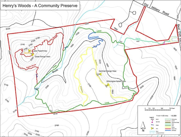
Henry’s Woods
The preserve has five interconnected trails, varying in difficulty:
• Connector Trail: This trail is the initial trail that accesses the trail network. The trail, which is 4-5 feet wide with a crushed stone surface, traverses mixed hardwood-conifer habitat, starting out flat and climbing slightly to the Loop Trail. This trail is about 0.3 miles in length.
• Loop Trail: This two-mile loop is the longest trail in the network and is used to access the Plateau, Switchback, and Rocky Knob Trails. The trail, which is 4-5 feet wide, has a crushed stone surface. The habitat is mixed hardwood-conifer forest. In a counter-clockwise direction, the trail drops slightly to cross a bridge, then circumnavigates a high plateau. On the back (southern) side of the loop, the trail climbs modestly to the top of the high plateau before descending back down to its beginning.
• Switchback Trail: This 0.25 mile trail is the shortest and steepest trails in the system. Starting from the Plateau Trail, the Switchback Trail descends slowly to the first switchback before a steeper grade is met with a couple more switchbacks. The trail exits onto the low side of the Loop Trail.
• Plateau Trail: This one mile trail is mostly flat and is accessed off the Loop Trail. Like the other trails, the Plateau Trail has a crushed stone surface. It follows along the edge of a long plateau and horseshoes back to the Loop Trail. There are outstanding views from a couple key points along the trail.
• Rocky Knob Trail: Accessed from the Loop Trail, the Rocky Knob Trail features the most difficult terrain of the system and climbs rather aggressively with several small switchbacks to alleviate the steepness in areas. It is rather rocky in spots and can be slippery underfoot. The high point of the trail system is along this trail and is formally known as Rocky Knob. From the summit there are great views of Village of Lake Placid and the surrounding area. The habitat is primarily hardwood forest.
11 íbúar mæla með
Henry's Woods
Bear Cub RoadHenry’s Woods
The preserve has five interconnected trails, varying in difficulty:
• Connector Trail: This trail is the initial trail that accesses the trail network. The trail, which is 4-5 feet wide with a crushed stone surface, traverses mixed hardwood-conifer habitat, starting out flat and climbing slightly to the Loop Trail. This trail is about 0.3 miles in length.
• Loop Trail: This two-mile loop is the longest trail in the network and is used to access the Plateau, Switchback, and Rocky Knob Trails. The trail, which is 4-5 feet wide, has a crushed stone surface. The habitat is mixed hardwood-conifer forest. In a counter-clockwise direction, the trail drops slightly to cross a bridge, then circumnavigates a high plateau. On the back (southern) side of the loop, the trail climbs modestly to the top of the high plateau before descending back down to its beginning.
• Switchback Trail: This 0.25 mile trail is the shortest and steepest trails in the system. Starting from the Plateau Trail, the Switchback Trail descends slowly to the first switchback before a steeper grade is met with a couple more switchbacks. The trail exits onto the low side of the Loop Trail.
• Plateau Trail: This one mile trail is mostly flat and is accessed off the Loop Trail. Like the other trails, the Plateau Trail has a crushed stone surface. It follows along the edge of a long plateau and horseshoes back to the Loop Trail. There are outstanding views from a couple key points along the trail.
• Rocky Knob Trail: Accessed from the Loop Trail, the Rocky Knob Trail features the most difficult terrain of the system and climbs rather aggressively with several small switchbacks to alleviate the steepness in areas. It is rather rocky in spots and can be slippery underfoot. The high point of the trail system is along this trail and is formally known as Rocky Knob. From the summit there are great views of Village of Lake Placid and the surrounding area. The habitat is primarily hardwood forest.
Heaven Hill Trails
There are three main loops and all of the paths are relatively flat and accessible.
• The Big Field Loop is 0.9 mile long and leads you through the woods to a field adjoining the Heaven Hill Farm property. This is the shortest of the trails and a fun little jog.
• The Old Orchard Loop is 1.4 miles long and marked by orange tags. It starts with a short walk through the woods which leads to a large loop through a field with outstanding views of the mountains. There is a slight grade on this loop.
• The Bear Cub Loop is marked in green and has the most options for varying its length. You can walk the main outer loop which runs 1.5 miles, or choose to shorten or lengthen your trip by taking one of the five shorter green cross trails.
14 íbúar mæla með
Heaven Hills Trails
470 Bear Cub RoadHeaven Hill Trails
There are three main loops and all of the paths are relatively flat and accessible.
• The Big Field Loop is 0.9 mile long and leads you through the woods to a field adjoining the Heaven Hill Farm property. This is the shortest of the trails and a fun little jog.
• The Old Orchard Loop is 1.4 miles long and marked by orange tags. It starts with a short walk through the woods which leads to a large loop through a field with outstanding views of the mountains. There is a slight grade on this loop.
• The Bear Cub Loop is marked in green and has the most options for varying its length. You can walk the main outer loop which runs 1.5 miles, or choose to shorten or lengthen your trip by taking one of the five shorter green cross trails.