
What you should not miss
Visite turistiche
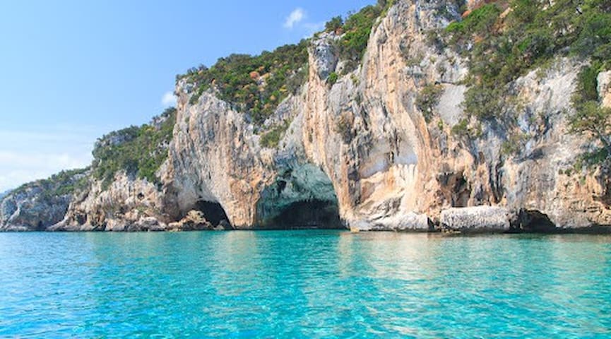
It’s a scenic 40-minute hike from Cala Fuili, or a speedy boat ride from Cala Gonone, to this enchanting grotto. It was the last island refuge of the rare monk seal (‘bue marino’ or ‘sea ox’ as it was known by local fishers). The watery gallery is impressive, with shimmering light playing on the strange shapes and Neolithic petroglyphs within the cave. Guided visits take place up to seven times a day. In peak season you may need to book at the Cala Gonone portside kiosk for 'Comune di Dorgali'. Note: boat tickets do not include entry tickets to the cave, which must be paid in cash.
61 íbúar mæla með
Grotta del Bue Marino
It’s a scenic 40-minute hike from Cala Fuili, or a speedy boat ride from Cala Gonone, to this enchanting grotto. It was the last island refuge of the rare monk seal (‘bue marino’ or ‘sea ox’ as it was known by local fishers). The watery gallery is impressive, with shimmering light playing on the strange shapes and Neolithic petroglyphs within the cave. Guided visits take place up to seven times a day. In peak season you may need to book at the Cala Gonone portside kiosk for 'Comune di Dorgali'. Note: boat tickets do not include entry tickets to the cave, which must be paid in cash.
In the centre of Sardinia, between Barbagia and Ogliastra, a deep chasm opens up, representing a spectacular, very valuable natural monument, based on its biodiversity and the endemism of plant and animal species.
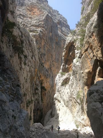
It is the most spectacular canyon in Europe and it is also one of the deepest: while driving down the eastern coast of Sardinia, you really must stop to visit it. Gorropu (or Gorroppu) is a gorge, created from erosion and located in the Supramonte area, between the territories of Orgosolo (Nuoro) and Urzulei (Ogliastra). It has been shaped over time by the force of the Rio Flumineddu rivulet that flows along its bed, at a depth of 500 metres. The width of the gorge varies from a few dozen metres to just four meters. You can reach it, departing from the Gorropu base camp, on the promontory of Su Cungiadeddu (altitude of 830 metres): in five minutes, you will be at the Genna Sìlana pass. From here, you can admire a unique landscape: from the Supramonte areas of Urzulei, Orgosolo, Oliena and Dorgali to Gennargentu and, on clear days, as far as Baronìa. It is the wildest territory on the Island: if you want to tackle its trails, place your trust in local hiking companies and equip yourself with technical equipment. The landscape is marked with long còdule - limestone gullies that sometimes stretch to the sea - narrow gorges and deep sinkholes, caves and ponors, cliff faces and peaks of over a thousand metres high. The area is covered with spectacular juniper trees, thousand-year-old yew trees, holm oak forests and Mediterranean species (among which oleanders and broom), is the habitat of typical Sardinian wildlife, like the golden eagle and the mouflon. There are also prehistoric remains: Nuragic villages and towers and Tombs of Giants, which blend into the environment and are positioned to watch over the territory.
You can reach the gorge along the Sedda ar Baccas-Gorroputrekking trail 'for experts', which is twelve kilometres long (in approximately three hours). Alternatively, you can leave Dorgali, crossing the valley of Oddoene (by car) until you reach the s'Abba Arvabridge and, from here, you can continue on foot for two hours, along a stretch of the Flumineddu river and the southeastern side of Mount Oddeu. These territories were the place of Sardinian resistance for centuries: the rulers had a difficult time here, as this was the area most hostile to Roman militia (Cicero's montes insani). The unusual nature of the place has generated legends: one tells us that, from the narrowest point of the gorge, where the vertical rock faces are over 450 metres high, you could see the stars in broad daylight. Or, it is said that the magical flowers of the 'male fern' bloom by night: only the bravest and greatest experts can pick them.
124 íbúar mæla með
Gorropu-gil
Località GorropuIn the centre of Sardinia, between Barbagia and Ogliastra, a deep chasm opens up, representing a spectacular, very valuable natural monument, based on its biodiversity and the endemism of plant and animal species.
It is the most spectacular canyon in Europe and it is also one of the deepest: while driving down the eastern coast of Sardinia, you really must stop to visit it. Gorropu (or Gorroppu) is a gorge, created from erosion and located in the Supramonte area, between the territories of Orgosolo (Nuoro) and Urzulei (Ogliastra). It has been shaped over time by the force of the Rio Flumineddu rivulet that flows along its bed, at a depth of 500 metres. The width of the gorge varies from a few dozen metres to just four meters. You can reach it, departing from the Gorropu base camp, on the promontory of Su Cungiadeddu (altitude of 830 metres): in five minutes, you will be at the Genna Sìlana pass. From here, you can admire a unique landscape: from the Supramonte areas of Urzulei, Orgosolo, Oliena and Dorgali to Gennargentu and, on clear days, as far as Baronìa. It is the wildest territory on the Island: if you want to tackle its trails, place your trust in local hiking companies and equip yourself with technical equipment. The landscape is marked with long còdule - limestone gullies that sometimes stretch to the sea - narrow gorges and deep sinkholes, caves and ponors, cliff faces and peaks of over a thousand metres high. The area is covered with spectacular juniper trees, thousand-year-old yew trees, holm oak forests and Mediterranean species (among which oleanders and broom), is the habitat of typical Sardinian wildlife, like the golden eagle and the mouflon. There are also prehistoric remains: Nuragic villages and towers and Tombs of Giants, which blend into the environment and are positioned to watch over the territory.
You can reach the gorge along the Sedda ar Baccas-Gorroputrekking trail 'for experts', which is twelve kilometres long (in approximately three hours). Alternatively, you can leave Dorgali, crossing the valley of Oddoene (by car) until you reach the s'Abba Arvabridge and, from here, you can continue on foot for two hours, along a stretch of the Flumineddu river and the southeastern side of Mount Oddeu. These territories were the place of Sardinian resistance for centuries: the rulers had a difficult time here, as this was the area most hostile to Roman militia (Cicero's montes insani). The unusual nature of the place has generated legends: one tells us that, from the narrowest point of the gorge, where the vertical rock faces are over 450 metres high, you could see the stars in broad daylight. Or, it is said that the magical flowers of the 'male fern' bloom by night: only the bravest and greatest experts can pick them.
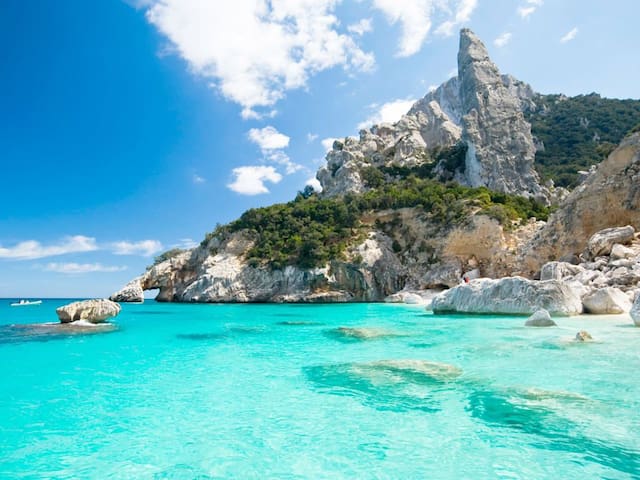
Cala Goloritze, a tiny but stunning beach at the base of a deep and pleasant ravine, is located just south of Cala Biriola, in the Ogliastra area, 9 kilometers north of Baunei.
Cala Goloritze beach is one of the most photogenic of its kind. It is only reachable on foot or by boat. If you’re planning on coming on foot, the hike to Cala Goloritze takes more than one hour, and the return trip will probably take you twice as long.
Do bring your snorkelling goggles, ease into the water and take a swim, spot some fish – the water features unbelievable shades of blue and green. Cala Goloritze is just another example of what Sardinian paradise looks like, and little compares with the uniqueness of this spot.
It should be no wonder that Cala Goloritze was elected a UNESCO site in 1995, and definitely is one of the best snorkeling beaches of Sardinia.
179 íbúar mæla með
Cala Goloritze
Cala Goloritze, a tiny but stunning beach at the base of a deep and pleasant ravine, is located just south of Cala Biriola, in the Ogliastra area, 9 kilometers north of Baunei.
Cala Goloritze beach is one of the most photogenic of its kind. It is only reachable on foot or by boat. If you’re planning on coming on foot, the hike to Cala Goloritze takes more than one hour, and the return trip will probably take you twice as long.
Do bring your snorkelling goggles, ease into the water and take a swim, spot some fish – the water features unbelievable shades of blue and green. Cala Goloritze is just another example of what Sardinian paradise looks like, and little compares with the uniqueness of this spot.
It should be no wonder that Cala Goloritze was elected a UNESCO site in 1995, and definitely is one of the best snorkeling beaches of Sardinia.
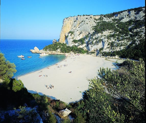
One of the wonders of the Gulf of Orosei, as well as the symbol of the eastern coast of Sardinia. Cala Luna is located half way between the territories of Baunei and Dorgali and is characterized by the mouth of the Codula di Luna torrent. Sheer rock faces protect and frame the cove, dotted with shady, spacious natural caves that offer shelter from the sun in the hottest months. The golden beach in the centre of the cove is washed by theclear blue, sea.
It is particularly popular with recreational underwater fishing enthusiasts or people who simply want to take a dip in its waters. It is equipped with a bar, a place for dining/refreshments and has shallow waters that makes it easy for children to play in the sea. The beach can be reached via sea, by boat, such as the boats departing from the nearest tourist ports (Cala Gonone, Santa Maria Navarrese and Arbatax). For trekking enthusiasts, the beach can be reached via a difficult trail (suitable for real experts), leaving from Cala Fiuli (Dorgali) or from Baunei. Because of its unusual beauty and wild charm, it was chosen as the setting for the film entitled 'Swept Away' by Lina Wertmuller, with Mariangela Melato and Giancarlo Giannini, an Italian cinema cult movie. It was also the setting for the remake of the film, starring the superstar, Madonna.
All around the bay, are the mountains of the Gulf of Gennargentu NationalPark, with their inaccessible peaks, the land whitened by pure white stones scattered all over the territory and large green valleys offering picturesque trekking trails. Holm oak, strawberry tree and oak woods create a picture-postcard landscape throughout the year, especially when spring and autumn bring with them a kaleidoscope of colours. Further south, along the gulf, in the territory of Baunei, you will find other havens with their unspoilt nature and crystal clear waters: the coves of Biriola, Sisine, Mariolu and Goloritzè,other corners of paradise that will remain in your memory for a long time and all of which can be reached by boat or via exciting trekking trails.
100 íbúar mæla með
Cala Luna
One of the wonders of the Gulf of Orosei, as well as the symbol of the eastern coast of Sardinia. Cala Luna is located half way between the territories of Baunei and Dorgali and is characterized by the mouth of the Codula di Luna torrent. Sheer rock faces protect and frame the cove, dotted with shady, spacious natural caves that offer shelter from the sun in the hottest months. The golden beach in the centre of the cove is washed by theclear blue, sea.
It is particularly popular with recreational underwater fishing enthusiasts or people who simply want to take a dip in its waters. It is equipped with a bar, a place for dining/refreshments and has shallow waters that makes it easy for children to play in the sea. The beach can be reached via sea, by boat, such as the boats departing from the nearest tourist ports (Cala Gonone, Santa Maria Navarrese and Arbatax). For trekking enthusiasts, the beach can be reached via a difficult trail (suitable for real experts), leaving from Cala Fiuli (Dorgali) or from Baunei. Because of its unusual beauty and wild charm, it was chosen as the setting for the film entitled 'Swept Away' by Lina Wertmuller, with Mariangela Melato and Giancarlo Giannini, an Italian cinema cult movie. It was also the setting for the remake of the film, starring the superstar, Madonna.
All around the bay, are the mountains of the Gulf of Gennargentu NationalPark, with their inaccessible peaks, the land whitened by pure white stones scattered all over the territory and large green valleys offering picturesque trekking trails. Holm oak, strawberry tree and oak woods create a picture-postcard landscape throughout the year, especially when spring and autumn bring with them a kaleidoscope of colours. Further south, along the gulf, in the territory of Baunei, you will find other havens with their unspoilt nature and crystal clear waters: the coves of Biriola, Sisine, Mariolu and Goloritzè,other corners of paradise that will remain in your memory for a long time and all of which can be reached by boat or via exciting trekking trails.
Cala di Cartoe beach (Spiaggia di Cala Cartoe), with its white sands and crystal clear waters, certainly deserves a spot in the list of most beautiful beaches of Sardinia and perhaps even on planet Earth. The beach is located just south of Marina di Orosei and Cala Osala di Dorgali, 4 kilometers off the SS 125 main road. Surrounded by rocks, overlooking the Gulf of Orosei, its waters are quite shallow, which makes the beach of Cala di Cartoe perfectly suitable for children.
Spiaggia di Cartoe
Cala di Cartoe beach (Spiaggia di Cala Cartoe), with its white sands and crystal clear waters, certainly deserves a spot in the list of most beautiful beaches of Sardinia and perhaps even on planet Earth. The beach is located just south of Marina di Orosei and Cala Osala di Dorgali, 4 kilometers off the SS 125 main road. Surrounded by rocks, overlooking the Gulf of Orosei, its waters are quite shallow, which makes the beach of Cala di Cartoe perfectly suitable for children.
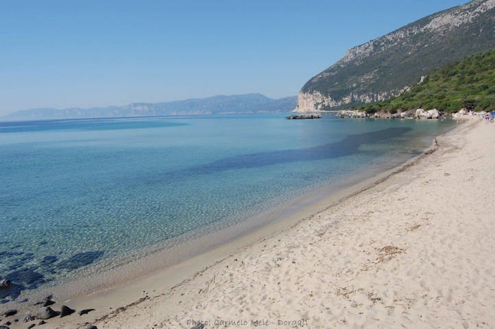
Cala Fuili is a beautiful beach located just up the coast from Cala Gonone. A short drive will take you to a small car park in which you can leave your car and stroll down the winding path to the beach. The beach itself is made up of mostly small stones and pebbles.
Cala Fuili has no facilities, so you may want to bring a beach chair and something for shade. A light parasol will do. The beach is sandy with small white pebbles around the water edge, so bring a pair of slippers or beach shoes. There isn’t a beach bar either, you’ll want to bring some food and drinks. Cala Fuili is one of the best beaches of East Sardinia, therefore the beach can get rather busy during high season, so it’s best to go there early if you can, preferably before 9 AM.
24 íbúar mæla með
Cala Fuili
Sentiero Cala Fuili - Cala LunaCala Fuili is a beautiful beach located just up the coast from Cala Gonone. A short drive will take you to a small car park in which you can leave your car and stroll down the winding path to the beach. The beach itself is made up of mostly small stones and pebbles.
Cala Fuili has no facilities, so you may want to bring a beach chair and something for shade. A light parasol will do. The beach is sandy with small white pebbles around the water edge, so bring a pair of slippers or beach shoes. There isn’t a beach bar either, you’ll want to bring some food and drinks. Cala Fuili is one of the best beaches of East Sardinia, therefore the beach can get rather busy during high season, so it’s best to go there early if you can, preferably before 9 AM.
One of the underground wonders of the Island is in the Nuoro area, in the centre of Sardinia, a cave very popular with tourists and speleologists from all over the world, with a limestone column almost 40 metres high.
A kaleidoscope of forms and colours from a mysterious past, within the bowels of the earth. A visit to Ispinigoli, in the Supramonte di Dorgali area, a few kilometres from the village, is an exciting and evocative descent taking you underground, to a room that is 80 metres in diameter and will strike you for its natural beauty and historical value. Inside the cave, which has been open to the public since 1974, you will walk along a well-equipped trail: the constant cool temperature - always 15 degrees - will accompany to you along the 280 steps of the descent. After going through the entrance, from the natural terrace, you will be captivated by a 38-metre high column, among the most impressive in Europe, a majestic limestone concretion that joins the vault to the base of the cave. It is the beginning of a beautiful sight that will captivate you. An exceptional environment in every detail: from the enormous concretions that stand out from the walls to the small and tiny stalagmites and the undulose formations. It is a game of colours and contrasts, getting gradually more intense as you go deeper down via the steps, brushing against the yellowish limestone with various forms and undertones, until you reach the base of the huge column.
Furthermore, in the 'Abyss of the Virgins', only expert speleologists can continue on. It is a narrow canal that is 60 metres deep, stretching for about 12 kilometres and connecting to the cave of San Giovanni Su Anzu. Basically, Ispinigoli is the part that can be visited of the entrance to an enormous karst system, with underground offshoots and streams. The chasm is of exceptional historical-archaeological interest: Nuragic, Punic and Roman findings have come to light, demonstrating its long use as a burial place and one of worship. Human remains have been found, as well as rings, necklaces and sun symbols, bringing to mind a Phoenician sacrificial well: human sacrifices may have taken place here. During the world wars, Ispinigoli was place of refuge and, until the middle of the 20th century, it was used by shepherd as a shelter for their flocks. Close to the cave, there is a hot water spring in which you can bathe and a well-known restaurant, where you can taste typical Sardinian cuisine.
The Supramonte area is one of the most remote treasure chests on the Island, dotted with towers, valleys springs and other deep caves. In order to complete the 'underground' tour, a boat trip in Dorgali, from the Grotte del Bue Marino, is a must, while in the adjacent territory of Oliena, you cannot miss out on a visit to Sa Oche and Su Bentu, one of the largest karst systems in Europe, and the Grotta Corbeddu cave, in the majestic valley of Lanaittu, that gets its name from a famous bandit who had his hideout here.
46 íbúar mæla með
Grotta di Ispinigoli
Località IspinigoliOne of the underground wonders of the Island is in the Nuoro area, in the centre of Sardinia, a cave very popular with tourists and speleologists from all over the world, with a limestone column almost 40 metres high.
A kaleidoscope of forms and colours from a mysterious past, within the bowels of the earth. A visit to Ispinigoli, in the Supramonte di Dorgali area, a few kilometres from the village, is an exciting and evocative descent taking you underground, to a room that is 80 metres in diameter and will strike you for its natural beauty and historical value. Inside the cave, which has been open to the public since 1974, you will walk along a well-equipped trail: the constant cool temperature - always 15 degrees - will accompany to you along the 280 steps of the descent. After going through the entrance, from the natural terrace, you will be captivated by a 38-metre high column, among the most impressive in Europe, a majestic limestone concretion that joins the vault to the base of the cave. It is the beginning of a beautiful sight that will captivate you. An exceptional environment in every detail: from the enormous concretions that stand out from the walls to the small and tiny stalagmites and the undulose formations. It is a game of colours and contrasts, getting gradually more intense as you go deeper down via the steps, brushing against the yellowish limestone with various forms and undertones, until you reach the base of the huge column.
Furthermore, in the 'Abyss of the Virgins', only expert speleologists can continue on. It is a narrow canal that is 60 metres deep, stretching for about 12 kilometres and connecting to the cave of San Giovanni Su Anzu. Basically, Ispinigoli is the part that can be visited of the entrance to an enormous karst system, with underground offshoots and streams. The chasm is of exceptional historical-archaeological interest: Nuragic, Punic and Roman findings have come to light, demonstrating its long use as a burial place and one of worship. Human remains have been found, as well as rings, necklaces and sun symbols, bringing to mind a Phoenician sacrificial well: human sacrifices may have taken place here. During the world wars, Ispinigoli was place of refuge and, until the middle of the 20th century, it was used by shepherd as a shelter for their flocks. Close to the cave, there is a hot water spring in which you can bathe and a well-known restaurant, where you can taste typical Sardinian cuisine.
The Supramonte area is one of the most remote treasure chests on the Island, dotted with towers, valleys springs and other deep caves. In order to complete the 'underground' tour, a boat trip in Dorgali, from the Grotte del Bue Marino, is a must, while in the adjacent territory of Oliena, you cannot miss out on a visit to Sa Oche and Su Bentu, one of the largest karst systems in Europe, and the Grotta Corbeddu cave, in the majestic valley of Lanaittu, that gets its name from a famous bandit who had his hideout here.
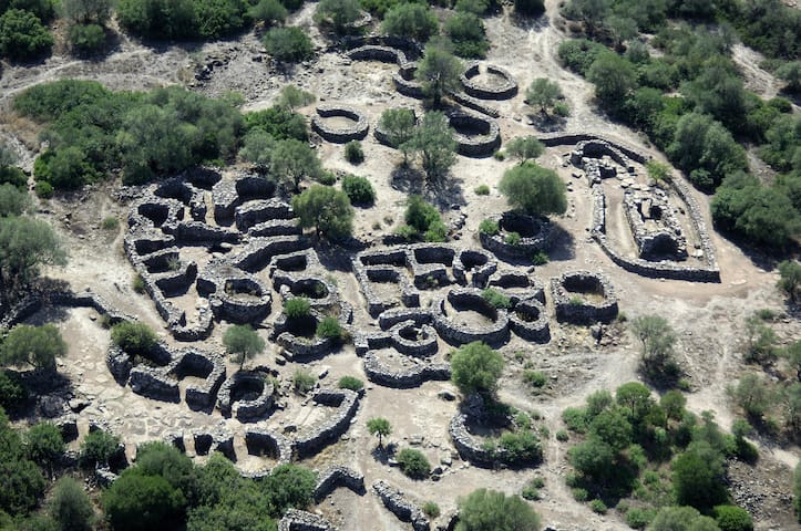
On a plateau overlooking the sea in central-eastern Sardinia, a very structured and well-preserved 'urban' site tells you about the life of the nuragic people.
It stands on the plateau of Gollei, in the territory of Dorgali, about ten kilometres from the town, surrounded by rugged hills, millennial olive trees and Mediterranean vegetation. Serra Orrios is one of the best preserved nuragic complexes: here, you can journey through time to a village-sanctuary, built entirely of basalt blocks, representing a purposefully designed proto-urban settlement in terms of size and architectural structure.
You can take a careful look at the well-preserved civil and cultural buildings of the nuragic age. The village consists of a hundred circular huts, built with a base of rows of stones and originally covered with branches. They are simple, or divided into different rooms - also to keep the animals, typical of a society dedicated to agriculture and breeding - overlooking a single courtyard with a well. Niches or closets have been created in the walls. The floors are in stone slabs, cobblestones or simple beaten earth. At the centre was a circular hearth, bordered by stones. Clay, and perhaps cork, was used to waterproof the buildings. The houses are grouped into three blocks, connected by small streets and squares. 'Hut 49' stands out, isolated, and may have been the 'meeting hut', characterized by a curvilinear layout and equipped with a bench-seat and an entrance vestibule.
The village-sanctuary, as well as two megalithic tombs, has two sacred areas, each with a megaron temple, a cult building typical of the Mycenaean civilization, which presupposes influences from the Aegean. The two small temples, perhaps dedicated to the water cult, have a rectangular layout equipped with a fence, each with an antechamber and a longitudinal cell, bordered by a bench-seat. One of the two areas is set apart from the town by a large circular enclosure; the other, with a well-preserved temple, is located inside the village, separated by a rectangular sacred enclosure.
The millenary life of the village of Serra Orrios began in the late Bronze Age (16th century BC) and ended in the Iron Age (9th to 6th century BC), and was centred around a market place and religious activities. Its most intense period of settlement was between the recent and final Bronze Age, as shown by numerous ceramic artefacts - cylindrical collared rings, bowls and decorated jugs - found in the excavations and preserved in the archaeological museum of Dorgali. These are now on display in the room dedicated to the nuragic civilization, together with frame weights, spindles and spools that demonstrate spinning and weaving activities, and clay stoves, drawers, smoothing stones, pestles, mills and casting matrices that testify an intense productive activity. Metal items found also include chisels, foundry springs, daggers, axes and ornaments (pins, bracelets, earrings, etc.).
From Serra Orrios you can easily reach other interesting nuragic settlements: the nearest are the Oveni and Purgatoriu nuraghes and the Giants' tombs of Biristeddi. The territory of Dorgali, one of the largest of the island (225 square kilometres), inhabited since the Paleolithic, is dotted with more than 200 Bronze Age sites: 45 nuraghes, one hundred settlements and about forty Giants' tombs, among which the most famous is s'Ena e Thomes, six kilometres from Serra Orrios, and a symbol of the nuragic age with its almost four metre-high stele. Among the villages it is impossible not to visit Tiscali, half in the territory of Oliena, which was a pre-nuragic site and later settled by indigenous communities (civitates Barbarie) open to traffic with the Italian peninsula. Regarding the 'towers', the Arvu and Mannu nuraghes stand out, overlooking Cala Fuili, and are both examples of reuse in Roman times. Around the Mannu nuraghe a Roman settlement spread out over two hectares, remaining active until the late imperial age. Some of the most significant pre-nuragic remains, dating back to the Neolithic, include 55 domus de Janas, among which those of Marras, Pirischè and Campu Marinu, as well as the dolmen of Motorra.
14 íbúar mæla með
Nuragic complex of Serra Orrios
On a plateau overlooking the sea in central-eastern Sardinia, a very structured and well-preserved 'urban' site tells you about the life of the nuragic people.
It stands on the plateau of Gollei, in the territory of Dorgali, about ten kilometres from the town, surrounded by rugged hills, millennial olive trees and Mediterranean vegetation. Serra Orrios is one of the best preserved nuragic complexes: here, you can journey through time to a village-sanctuary, built entirely of basalt blocks, representing a purposefully designed proto-urban settlement in terms of size and architectural structure.
You can take a careful look at the well-preserved civil and cultural buildings of the nuragic age. The village consists of a hundred circular huts, built with a base of rows of stones and originally covered with branches. They are simple, or divided into different rooms - also to keep the animals, typical of a society dedicated to agriculture and breeding - overlooking a single courtyard with a well. Niches or closets have been created in the walls. The floors are in stone slabs, cobblestones or simple beaten earth. At the centre was a circular hearth, bordered by stones. Clay, and perhaps cork, was used to waterproof the buildings. The houses are grouped into three blocks, connected by small streets and squares. 'Hut 49' stands out, isolated, and may have been the 'meeting hut', characterized by a curvilinear layout and equipped with a bench-seat and an entrance vestibule.
The village-sanctuary, as well as two megalithic tombs, has two sacred areas, each with a megaron temple, a cult building typical of the Mycenaean civilization, which presupposes influences from the Aegean. The two small temples, perhaps dedicated to the water cult, have a rectangular layout equipped with a fence, each with an antechamber and a longitudinal cell, bordered by a bench-seat. One of the two areas is set apart from the town by a large circular enclosure; the other, with a well-preserved temple, is located inside the village, separated by a rectangular sacred enclosure.
The millenary life of the village of Serra Orrios began in the late Bronze Age (16th century BC) and ended in the Iron Age (9th to 6th century BC), and was centred around a market place and religious activities. Its most intense period of settlement was between the recent and final Bronze Age, as shown by numerous ceramic artefacts - cylindrical collared rings, bowls and decorated jugs - found in the excavations and preserved in the archaeological museum of Dorgali. These are now on display in the room dedicated to the nuragic civilization, together with frame weights, spindles and spools that demonstrate spinning and weaving activities, and clay stoves, drawers, smoothing stones, pestles, mills and casting matrices that testify an intense productive activity. Metal items found also include chisels, foundry springs, daggers, axes and ornaments (pins, bracelets, earrings, etc.).
From Serra Orrios you can easily reach other interesting nuragic settlements: the nearest are the Oveni and Purgatoriu nuraghes and the Giants' tombs of Biristeddi. The territory of Dorgali, one of the largest of the island (225 square kilometres), inhabited since the Paleolithic, is dotted with more than 200 Bronze Age sites: 45 nuraghes, one hundred settlements and about forty Giants' tombs, among which the most famous is s'Ena e Thomes, six kilometres from Serra Orrios, and a symbol of the nuragic age with its almost four metre-high stele. Among the villages it is impossible not to visit Tiscali, half in the territory of Oliena, which was a pre-nuragic site and later settled by indigenous communities (civitates Barbarie) open to traffic with the Italian peninsula. Regarding the 'towers', the Arvu and Mannu nuraghes stand out, overlooking Cala Fuili, and are both examples of reuse in Roman times. Around the Mannu nuraghe a Roman settlement spread out over two hectares, remaining active until the late imperial age. Some of the most significant pre-nuragic remains, dating back to the Neolithic, include 55 domus de Janas, among which those of Marras, Pirischè and Campu Marinu, as well as the dolmen of Motorra.
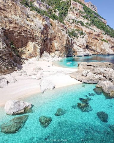
A real jewel in the Gulf of Orosei, on the central-eastern coast of Sardinia: a welcoming little cove featuring pink and white pebbles rewarding you abundantly after a walk through the wild nature or a boat trip.
Dive into this sea that looks like it has been painted. It is also known as ispùligi de nie (snow fleas) because it consists of small round, pink and white pebbles, mixed with sand. Cala Mariolu, in the territory of Baunei, gets its name from the Mediterranean monk seal that is said to have ‘stolen’ the fish from the nets of the fishermen from Ponza and was therefore called the mariolo (thief).
Its landscape is striking, with its endless shades of blue, emerald green and sky-blue, as well as its pebbles that resemble snowflakes. The cliff surrounding it reaches a height of 500 metres and looks out onto the sea both to the north and to the south, making Cala Mariolu accessible from the land only via a challenging trekking trail (for experts) through dense Mediterranean scrub. In the past, Punta Is Puligi acted as a place in which coal could be loading by the furisteris, the coal merchants who populated the Baunei area.
The seabed with its shallow waters is worth exploring with a mask, for those who have less familiarity, or with diving equipment for those who want to explore its depths: it is the habitat of various species. You can even catch a glimpse of dolphins offshore from time to time. Out of the water, you will see the peregrine falcon and the Eleonora's falcon, the European shag and the golden eagle.
A large rock, sa perda 'e su saltatori, acts as a pier. In fact, the cove is easier to get to via the sea, in private boats or using services heading to the coves that depart from the ports of Arbatax, Cala Gonone and Santa Maria Navarrese. Nearby, there are numerous caves, one of which is in the cove: it begins with a little beach and is ten metres deep, which is the result of the incessant movement of the sea over the centuries. Not far away, there is the charming Grotta del Fico. During your trip along the gulf, there are other little coves not to be missed: the unspoilt Cala Goloritzè, the splendid Cala Sisine and Cala Biriola and one of the beaches symbolizing the Mediterranean, Cala Luna, halfway between here and the territory of Dorgali.
32 íbúar mæla með
Cala Mariolu
A real jewel in the Gulf of Orosei, on the central-eastern coast of Sardinia: a welcoming little cove featuring pink and white pebbles rewarding you abundantly after a walk through the wild nature or a boat trip.
Dive into this sea that looks like it has been painted. It is also known as ispùligi de nie (snow fleas) because it consists of small round, pink and white pebbles, mixed with sand. Cala Mariolu, in the territory of Baunei, gets its name from the Mediterranean monk seal that is said to have ‘stolen’ the fish from the nets of the fishermen from Ponza and was therefore called the mariolo (thief).
Its landscape is striking, with its endless shades of blue, emerald green and sky-blue, as well as its pebbles that resemble snowflakes. The cliff surrounding it reaches a height of 500 metres and looks out onto the sea both to the north and to the south, making Cala Mariolu accessible from the land only via a challenging trekking trail (for experts) through dense Mediterranean scrub. In the past, Punta Is Puligi acted as a place in which coal could be loading by the furisteris, the coal merchants who populated the Baunei area.
The seabed with its shallow waters is worth exploring with a mask, for those who have less familiarity, or with diving equipment for those who want to explore its depths: it is the habitat of various species. You can even catch a glimpse of dolphins offshore from time to time. Out of the water, you will see the peregrine falcon and the Eleonora's falcon, the European shag and the golden eagle.
A large rock, sa perda 'e su saltatori, acts as a pier. In fact, the cove is easier to get to via the sea, in private boats or using services heading to the coves that depart from the ports of Arbatax, Cala Gonone and Santa Maria Navarrese. Nearby, there are numerous caves, one of which is in the cove: it begins with a little beach and is ten metres deep, which is the result of the incessant movement of the sea over the centuries. Not far away, there is the charming Grotta del Fico. During your trip along the gulf, there are other little coves not to be missed: the unspoilt Cala Goloritzè, the splendid Cala Sisine and Cala Biriola and one of the beaches symbolizing the Mediterranean, Cala Luna, halfway between here and the territory of Dorgali.
S’ABBA FRISCA PARK-MUSEUM A dip into the past to rediscover identity. S’Abba Frisca park-museum takes its name from our freshwater spring. The itinerary has two themes: natural and ethnographic, woven together in one journey. The museum has more than 4,000 items from farming and grazing life in 15 locations. The guided visit winds through plants used in folk medicine, dyeing and construction, among fountains, cascades and giant-stone pathways. Here there are mallard and other ducks, water hen, and tortoises living in water and on land. Among the museum buildings, there is the shepherd’s hut built more than a century ago of basalt blocks and juniper wood, copying the circular form of huts typical of the Nuragic era. Also: the enclosure for goats; the farmer’s courtyard with grindstone turned by a donkey; the blacksmith’s courtyard with bellows from the 1800s. Bedrooms with storage chests from the 1700s; the room for spinning and weaving with antique looms; clothing of times gone by for daily life and festive occasions; armaments, jewellery and musical instruments. The itinerary finishes in the kitchen for Sardinian breadmaking, where the secrets of this shepherds’ bread are revealed.
15 íbúar mæla með
Parco Museo S'Abba Frisca
S’ABBA FRISCA PARK-MUSEUM A dip into the past to rediscover identity. S’Abba Frisca park-museum takes its name from our freshwater spring. The itinerary has two themes: natural and ethnographic, woven together in one journey. The museum has more than 4,000 items from farming and grazing life in 15 locations. The guided visit winds through plants used in folk medicine, dyeing and construction, among fountains, cascades and giant-stone pathways. Here there are mallard and other ducks, water hen, and tortoises living in water and on land. Among the museum buildings, there is the shepherd’s hut built more than a century ago of basalt blocks and juniper wood, copying the circular form of huts typical of the Nuragic era. Also: the enclosure for goats; the farmer’s courtyard with grindstone turned by a donkey; the blacksmith’s courtyard with bellows from the 1800s. Bedrooms with storage chests from the 1700s; the room for spinning and weaving with antique looms; clothing of times gone by for daily life and festive occasions; armaments, jewellery and musical instruments. The itinerary finishes in the kitchen for Sardinian breadmaking, where the secrets of this shepherds’ bread are revealed.
The giants' grave of S'Ena'e Thomes is a nuragic-era archaeological site located in the municipality of Dorgali, in the province of Nuoro, Sardinia.
The tomb, dating back to the Bronze Age, has a dolmen structure with a central stele. The large exedra is composed of slabs stuck into the ground and sorted by descending size from the stele. The funeral hall, rectangular in shape and about 11 m length, is covered with large stone slabs arranged in a Jack arch.
11 íbúar mæla með
Giants' grave of S'Ena'e Thomes
Km 19 Strada Provinciale 38The giants' grave of S'Ena'e Thomes is a nuragic-era archaeological site located in the municipality of Dorgali, in the province of Nuoro, Sardinia.
The tomb, dating back to the Bronze Age, has a dolmen structure with a central stele. The large exedra is composed of slabs stuck into the ground and sorted by descending size from the stele. The funeral hall, rectangular in shape and about 11 m length, is covered with large stone slabs arranged in a Jack arch.
In the water park in Dorgali, on the central-eastern coast of Sardinia, the underwater worlds of the Mediterranean along with those of other seas and oceans can be explored.
This is the largest and most modern structure of its kind in Sardinia. The aquarium of Cala Gonone, built in 2010 in the coastal village of Dorgali and set within a green park to symbolise the transition from the mountains of Supramonte to the sea, unites educational aspect (and environmental protection) with fun. You will be ‘immersed’ in 24 display tanks on a journey from the shore to the depths of the sea, passing rocky coasts and the open sea dominated by jellyfish, large snappers and sharks. This is a representation of the main marine habitats of the Mediterranean. You can come across the world of trumpetfish, see the camouflage capabilities of cuttlefish and octopus, dive into the dark hideouts and other spectacular environments of the Gulf of Orosei. In one of the most spectacular pools, dark rocks reproduce columnar basalt with an opening that has become a lair for eels and moray eels, whilst the lateral ‘terraces’ are home to scorpion fish. The open sea basin is the largest, divided into three sections across a number of levels - the first being naturally lit, the other two artificially illuminated to represent the kingdom of large pelagic fish, also home to sea urchins. A loggerhead sea turtle also lives here. Mediterranean and beyond: in the first pool, the only freshwater one, you will see the voracious piranhas, In the tropical seawater pools are a range of species in amazing shapes and bright colours that live in coral reefs. Tropical basins tell the story of the origin of an atoll and cases of evolutionary adaptations and symbiosis. The route ends with the tactile tub - learn to fearlessly feel a fish and touch sea urchins, starfish and hermit crabs.
After this ‘dive’ into aquarium life, the village of Cala Gonone can be explored, nestled on a steep hill that slopes down to the sea, an attraction for lovers of nature and adventure or for romantic boat trips. Relax on the golden sands of Cala Cartoe, Ziu Martine and Cala Osalla or, by the sea or on a trekking adventure, you can reach Cala Luna, the ‘pearl’ of the Mediterranean. A guided excursion will take you to the Grotte del Bue Marino, a spectacular ‘forest’ of stalactites and stalagmites, once the habitat of the monk seal, the evocative setting of the Cala Gonone Jazz festival. From the coast to the hinterland of Dorgali: cultural, food and wine traditions, archaeological attractions, including the museum housing the remnants of the Nuragic village-sanctuary of Serra Òrrios, with crafts (such as filigree jewellery and ceramics) and monuments of worship, or the churches of Madonna d’Itria and Santa Caterina. To be discovered is a natural heritage extending over 225 square kilometres, with the pride and joy of the Supramonte, the Valle del Cedrino and the Valle di Lanaittu.
36 íbúar mæla með
Cala Gonone Aquarium
Via La FavoritaIn the water park in Dorgali, on the central-eastern coast of Sardinia, the underwater worlds of the Mediterranean along with those of other seas and oceans can be explored.
This is the largest and most modern structure of its kind in Sardinia. The aquarium of Cala Gonone, built in 2010 in the coastal village of Dorgali and set within a green park to symbolise the transition from the mountains of Supramonte to the sea, unites educational aspect (and environmental protection) with fun. You will be ‘immersed’ in 24 display tanks on a journey from the shore to the depths of the sea, passing rocky coasts and the open sea dominated by jellyfish, large snappers and sharks. This is a representation of the main marine habitats of the Mediterranean. You can come across the world of trumpetfish, see the camouflage capabilities of cuttlefish and octopus, dive into the dark hideouts and other spectacular environments of the Gulf of Orosei. In one of the most spectacular pools, dark rocks reproduce columnar basalt with an opening that has become a lair for eels and moray eels, whilst the lateral ‘terraces’ are home to scorpion fish. The open sea basin is the largest, divided into three sections across a number of levels - the first being naturally lit, the other two artificially illuminated to represent the kingdom of large pelagic fish, also home to sea urchins. A loggerhead sea turtle also lives here. Mediterranean and beyond: in the first pool, the only freshwater one, you will see the voracious piranhas, In the tropical seawater pools are a range of species in amazing shapes and bright colours that live in coral reefs. Tropical basins tell the story of the origin of an atoll and cases of evolutionary adaptations and symbiosis. The route ends with the tactile tub - learn to fearlessly feel a fish and touch sea urchins, starfish and hermit crabs.
After this ‘dive’ into aquarium life, the village of Cala Gonone can be explored, nestled on a steep hill that slopes down to the sea, an attraction for lovers of nature and adventure or for romantic boat trips. Relax on the golden sands of Cala Cartoe, Ziu Martine and Cala Osalla or, by the sea or on a trekking adventure, you can reach Cala Luna, the ‘pearl’ of the Mediterranean. A guided excursion will take you to the Grotte del Bue Marino, a spectacular ‘forest’ of stalactites and stalagmites, once the habitat of the monk seal, the evocative setting of the Cala Gonone Jazz festival. From the coast to the hinterland of Dorgali: cultural, food and wine traditions, archaeological attractions, including the museum housing the remnants of the Nuragic village-sanctuary of Serra Òrrios, with crafts (such as filigree jewellery and ceramics) and monuments of worship, or the churches of Madonna d’Itria and Santa Caterina. To be discovered is a natural heritage extending over 225 square kilometres, with the pride and joy of the Supramonte, the Valle del Cedrino and the Valle di Lanaittu.
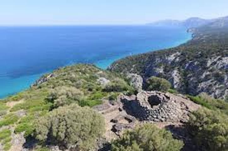
Nuraghe Mannu is a nuragic archaeological site located about 180 metres (590 ft) above sea level overlooking the village of Cala Gonone. It is located on the east coast of Sardinia, in the middle of the gulf of Orosei, province of Nuoro and the municipality of Dorgali.
20 íbúar mæla með
Nuraghe Mannu
Nuraghe Mannu is a nuragic archaeological site located about 180 metres (590 ft) above sea level overlooking the village of Cala Gonone. It is located on the east coast of Sardinia, in the middle of the gulf of Orosei, province of Nuoro and the municipality of Dorgali.