
Vickie’s guidebook
great walking track
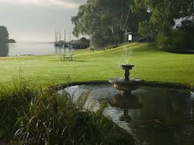
The Richard Gutteridge Memorial Gardens lie at the end of the main street of Wynyard, and provide cycling and walking tracks along with seating areas and BBQ shelters. Public toilets are available next to the main car park overlooking the main stage area – which is used for events such as the Tulip Festival and Australia Day Breakfast.
This is the official starting point of the Inglis River Track – a 12km walking track along the river’s edge. A memorial cenotaph is located in parkland overlooking the Inglis River and at the Northern end of the Gardens there is a boat ramp (accessed off Jenner Street) for launching large vessels.
Facility Snapshot
Features
Disabled Toilets
Electric BBQs
Free Parking
Picnic Tables
Public Toilets
12 íbúar mæla með
Wynyard
The Richard Gutteridge Memorial Gardens lie at the end of the main street of Wynyard, and provide cycling and walking tracks along with seating areas and BBQ shelters. Public toilets are available next to the main car park overlooking the main stage area – which is used for events such as the Tulip Festival and Australia Day Breakfast.
This is the official starting point of the Inglis River Track – a 12km walking track along the river’s edge. A memorial cenotaph is located in parkland overlooking the Inglis River and at the Northern end of the Gardens there is a boat ramp (accessed off Jenner Street) for launching large vessels.
Facility Snapshot
Features
Disabled Toilets
Electric BBQs
Free Parking
Picnic Tables
Public Toilets
The magnificent plateau of Table Cape is by far Wynyard's most remarkable natural wonder. Sitting at 180 metres high, 'The Cape' - as locals refer to it - dominates the Wynyard coastline and offers spectacular views of Tasmania's coast and agricultural farmlands. As you drive to the top of the remains of a 12 million-year-old volcano you'll reach a viewing platform where, on a clear day, you can see George Town's Low Head and mountain ranges over 175 kilometres away. Take a short stroll along the cliff-top walking track to the Table Cape Lighthouse, the only operating lighthouse open (seasonally) for tours in mainland Tasmania.
Table Cape is also home to the Table Cape Tulip Farm where acres of patchwork fields explode with colour each spring. This is a sight that will leave you breathless, so be sure to add a trip to Wynyard and Table Cape to your itinerary this spring.
7 íbúar mæla með
Table Cape
The magnificent plateau of Table Cape is by far Wynyard's most remarkable natural wonder. Sitting at 180 metres high, 'The Cape' - as locals refer to it - dominates the Wynyard coastline and offers spectacular views of Tasmania's coast and agricultural farmlands. As you drive to the top of the remains of a 12 million-year-old volcano you'll reach a viewing platform where, on a clear day, you can see George Town's Low Head and mountain ranges over 175 kilometres away. Take a short stroll along the cliff-top walking track to the Table Cape Lighthouse, the only operating lighthouse open (seasonally) for tours in mainland Tasmania.
Table Cape is also home to the Table Cape Tulip Farm where acres of patchwork fields explode with colour each spring. This is a sight that will leave you breathless, so be sure to add a trip to Wynyard and Table Cape to your itinerary this spring.
A magnet for beach ramblers and rock climbers
Nudging out to Bass Strait Rocky Cape National Park offers spectacular views from many points along its walking tracks. Aboriginal heritage, ship wrecks, rock formations and rolling hills of wilderness are just some of the spectacular sights you’ll find in this rugged wilderness. Listed below are what Rocky Cape National Park is famous for.
Wildlife
Native wildlife is abundant throughout this park. Treading carefully and with a torch, evenings make the perfect time meet wallabies, wombats and possums.
Flora and Fauna
In spring and summer see the hundreds of different plant species in flower, most of them wind, salt and fire tolerant surviving the wild coastal conditions. Many of the 40 orchid species are found in the park, many of which lie dormant underground until fire passes.
Bush walks
Rocky Cape National Park offers a variety of walks ranging from less than 20 minutes to a full day. These take in Aboriginal rock shelters and caves, scenic hills full of wildflowers and birds, and tranquil beaches, bays and rocky headland.
Below are two of our favourite walks - there are many more walks in the National Park. Go to visitcradlecoast.com.au (Short walks in Rocky Cape National Park, Tasmania) for more information.
Banksia Grove/Caves Circuit
Up to 1 hour return, approximately 1.6km: A clearly defined track near the Sisters Beach boat ramp climbs into the heath-covered hills. You soon reach Banksia Grove, an extensive stand of saw banksias with spectacularly large cylindrical flowers. When these ripen they develop seed capsules along the drying flowers. These capsules give mature flowers the face-like features which author May Gibbs fictionalised as her 'bad banksia men'.
From Banksia Grove take the link track towards the coast. Here you'll find an Aboriginal shelter, Lee Archer Cave, set dramatically above the rocky shore. A platform allows viewing of the cave while protecting midden material. Please keep to this platform.
After returning to the junction, climb steeply down to Wet Cave. Towards the rear of this aptly named cave you will often find a pool of water. From the cave the track drops down to the coast. A rock-hop of 100m or so leads back to the Sisters Beach boat ramp.
Postmans Track
1 hour one way; 2 1/2 hours return, 2.1km one way: Named after the route used for horseback postal deliveries early this century, this track circles the easternmost section of the park, near Sisters Beach. Leaving from the roadside near Lake Llewellyn, the signposted track climbs east into the wooded hills known as the Two Sisters, making a wide sweep of them before reaching the cliffs above Walkers Cove. The track returns to the eastern end of Sisters Beach. It is a comfortable 1 - 1 1/2 hour walk if cars are left at each end. Alternatively continue along the beach until you reach the road and return to your starting point, making a 2 - 2 1/2 hour circuit.
25 íbúar mæla með
Rocky Cape National Park
A magnet for beach ramblers and rock climbers
Nudging out to Bass Strait Rocky Cape National Park offers spectacular views from many points along its walking tracks. Aboriginal heritage, ship wrecks, rock formations and rolling hills of wilderness are just some of the spectacular sights you’ll find in this rugged wilderness. Listed below are what Rocky Cape National Park is famous for.
Wildlife
Native wildlife is abundant throughout this park. Treading carefully and with a torch, evenings make the perfect time meet wallabies, wombats and possums.
Flora and Fauna
In spring and summer see the hundreds of different plant species in flower, most of them wind, salt and fire tolerant surviving the wild coastal conditions. Many of the 40 orchid species are found in the park, many of which lie dormant underground until fire passes.
Bush walks
Rocky Cape National Park offers a variety of walks ranging from less than 20 minutes to a full day. These take in Aboriginal rock shelters and caves, scenic hills full of wildflowers and birds, and tranquil beaches, bays and rocky headland.
Below are two of our favourite walks - there are many more walks in the National Park. Go to visitcradlecoast.com.au (Short walks in Rocky Cape National Park, Tasmania) for more information.
Banksia Grove/Caves Circuit
Up to 1 hour return, approximately 1.6km: A clearly defined track near the Sisters Beach boat ramp climbs into the heath-covered hills. You soon reach Banksia Grove, an extensive stand of saw banksias with spectacularly large cylindrical flowers. When these ripen they develop seed capsules along the drying flowers. These capsules give mature flowers the face-like features which author May Gibbs fictionalised as her 'bad banksia men'.
From Banksia Grove take the link track towards the coast. Here you'll find an Aboriginal shelter, Lee Archer Cave, set dramatically above the rocky shore. A platform allows viewing of the cave while protecting midden material. Please keep to this platform.
After returning to the junction, climb steeply down to Wet Cave. Towards the rear of this aptly named cave you will often find a pool of water. From the cave the track drops down to the coast. A rock-hop of 100m or so leads back to the Sisters Beach boat ramp.
Postmans Track
1 hour one way; 2 1/2 hours return, 2.1km one way: Named after the route used for horseback postal deliveries early this century, this track circles the easternmost section of the park, near Sisters Beach. Leaving from the roadside near Lake Llewellyn, the signposted track climbs east into the wooded hills known as the Two Sisters, making a wide sweep of them before reaching the cliffs above Walkers Cove. The track returns to the eastern end of Sisters Beach. It is a comfortable 1 - 1 1/2 hour walk if cars are left at each end. Alternatively continue along the beach until you reach the road and return to your starting point, making a 2 - 2 1/2 hour circuit.
Sightseeing
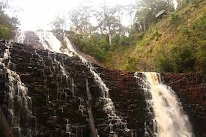
Dip Falls is one of the most beautiful waterfalls in the state. It's two-tiered structure and unique rock formations make it well worth a visit.
From the parking area next to the falls in the Dip Falls Reserve, it's a short walk to a platform with an unsurpassed view out over the top of the falls. Another path leads down some steps to the base of the falls and its unique rock formations.
Like other waterfalls, Dip Falls is at its most impressive after rain and is best viewed in winter.
From the car park you can also walk 5 min to the Big Tree in the Big Tree Reserve. The circumference of the tree at its base is nearly 17 m and definitely worth a look if you're here.
Dip Falls is between Stanley and Wynyard in Tasmania's North West, 27 km up a quiet and mostly sealed road that passes through pleasant countryside.
Both the falls and Big Tree Reserve are suitable for disabled access. BBQ facilities and toilets are provided.
Dip Falls Road
Dip Falls RoadDip Falls is one of the most beautiful waterfalls in the state. It's two-tiered structure and unique rock formations make it well worth a visit.
From the parking area next to the falls in the Dip Falls Reserve, it's a short walk to a platform with an unsurpassed view out over the top of the falls. Another path leads down some steps to the base of the falls and its unique rock formations.
Like other waterfalls, Dip Falls is at its most impressive after rain and is best viewed in winter.
From the car park you can also walk 5 min to the Big Tree in the Big Tree Reserve. The circumference of the tree at its base is nearly 17 m and definitely worth a look if you're here.
Dip Falls is between Stanley and Wynyard in Tasmania's North West, 27 km up a quiet and mostly sealed road that passes through pleasant countryside.
Both the falls and Big Tree Reserve are suitable for disabled access. BBQ facilities and toilets are provided.