
Elizabeth's Guidebook
Great Restaurants
Some places the locals eat at
coffee shop in the village, this is where the locals go, great for breakfast
43 íbúar mæla með
Rambling Rose Tea Garden & Coffee Shop
165 St Francis Drcoffee shop in the village, this is where the locals go, great for breakfast
Right on the canals, awesome experience, go for a boat ride, hire a canoe or paddleboard. enjoy the canals and then have lunch and drinks on the deck
28 íbúar mæla með
Quaysyde Restaurant
15 Sea Glades DrRight on the canals, awesome experience, go for a boat ride, hire a canoe or paddleboard. enjoy the canals and then have lunch and drinks on the deck
This is a local favourite Amazing burgers, great specials on certain days, grassy play area for kids. Quick walk to the beach
14 íbúar mæla með
Full Stop Cafe
Da Gama RoadThis is a local favourite Amazing burgers, great specials on certain days, grassy play area for kids. Quick walk to the beach
Great Restaurants
The Brewery is really close by and often has live bands at weekends. They have great local Craft Beers and Gin. The Chef is excellent.
36 íbúar mæla með
St Francis Brewing Co
171 St Francis DrThe Brewery is really close by and often has live bands at weekends. They have great local Craft Beers and Gin. The Chef is excellent.
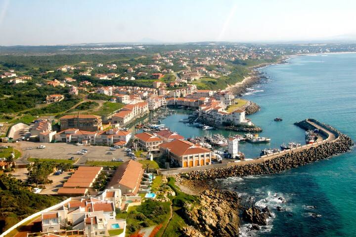
St Francis Bay
At the end of the garden route, just like at the end of the rainbow, you can find your pot of gold.
This hidden treasure is St Francis Bay, a magnetic paradise that rolls out between the magnificent
green wilderness of the Baviaanskloof mountains and the deep blue Indian ocean. St Francis Bay
draws people to visit from far and wide and casts a spell that makes them want to stay forever.
It’s no joke, take a look around. St Francis is blessed with a tremendous stretch of pristine natural
coastline, it has long sandy beaches, an enchanting canal system, a river, and an estuary. There is a
port, an airpark, and a lighthouse. There are archeological sites and numerous nature reserves that
form part of the Cape floral kingdom. Otters and Dolphins are spotted daily and during winter
months the bay becomes a nursery for Southern Right and Humpback Whales. Over 200 species of
indigenous birds fill the beaches and skies, from Flamingo's to Fish Eagles, not to mention an
accidental colony of escaped Lovebirds, now living wild in the palm trees. St Francis Bay feels like
one of the greatest places on earth.
The Kromme River bridge is perhaps the grand entrance to St Francis Bay. Dozens of monochromatic
mansions lined up along a mirror of riverfront. This is the face of St Francis, neat and clean, white
walls and grey roofs. Originally a village of little old-world thatch cottages with wide green spaces in
between. St Francis is now growing in popularity and the spaces are quickly being filled with larger
more contemporary homes finished with the newly favoured tile roofs in the uniform grey.
Settling of St Francis began in 1954 with Leighton (sugar) Hulett from Natal. Mr Hullet saw an ad that
described a fisherman's paradise, lonely, isolated, well wooded and watered, plus two miles of
private beach for £1750, making a great decision he bought the farm and moved here with his
young family. Leighton first created a fishing camp for visitors, but as time passed by, he sold pieces
of land to interested buyers. It was Leighton who stipulated the strict white walls and thatch or grey
roof building codes you see in place today.
The town’s total population is now around 12k that number can reach about 50k during holiday
seasons. Hundreds of South Africans, including a few celebs own holiday homes here, which has the
town overflowing with a jolly crowd in the summertime. St Francis Bay is family fabulous, and many
locals that leave for greener grass, only return here later to raise a family.
This is where dreams come home.
The Ace card for St Francis Bay is the canals, back in 1967 it was again Leighton who developed the
area that is now St Francis Canals. This enchanting maze of waterways is the summer playground of
the rich. The canals were originally dredged for Hullet family water-skiing, but were later lined with
plots and today house prices go up to R45m. This piece of real estate genius is now stacked with
over 600 holiday homes, 90% of them unoccupied and perched on the edge of the tidal waterways
waiting patiently for summer. To truly appreciate the grandeur of these homes, the canals must be
seen from a paddleboard, canoe or boat. You can hire these at Quaysyde on the canals. This little
family restaurant is owned by second generation Nevil Hullet, and hosts many local sporting events,
running, swimming and the King of the Kromme paddle race. The canal system measures 50km in
total and opens into the Kromme river estuary at two points. The Kromme river is navigable for a
further 10 km upstream.
St Francis is a big attraction for international sportsmen and women. In 1965 surfing movie Endless
Summer starred the perfect waves of Bruce's Beauties, these waves can be found to the right of
Granny’s pool and still bring surfers to town. The much-loved old Village Golf course forms the green
heart of the village and was funded by Leighton in 1975, and St Francis Links Golf Course and ifestyle
Estate, designed by the great Jack Nicklaus attracts international golfers all year. You can play
squash, tennis or bowls in the village. You can enjoy deep-sea fishing or a whale watching trip or just
witness the launch of one of the world-famous catamarans which are assembled here. There is every
kind of race, cycling, running, paddling, swimming, beer, walking, but you will not find a rat race, the
town has one supermarket and one petrol-station and they only operate in daylight hours.
45 íbúar mæla með
Saint Francis Bay
At the end of the garden route, just like at the end of the rainbow, you can find your pot of gold.
This hidden treasure is St Francis Bay, a magnetic paradise that rolls out between the magnificent
green wilderness of the Baviaanskloof mountains and the deep blue Indian ocean. St Francis Bay
draws people to visit from far and wide and casts a spell that makes them want to stay forever.
It’s no joke, take a look around. St Francis is blessed with a tremendous stretch of pristine natural
coastline, it has long sandy beaches, an enchanting canal system, a river, and an estuary. There is a
port, an airpark, and a lighthouse. There are archeological sites and numerous nature reserves that
form part of the Cape floral kingdom. Otters and Dolphins are spotted daily and during winter
months the bay becomes a nursery for Southern Right and Humpback Whales. Over 200 species of
indigenous birds fill the beaches and skies, from Flamingo's to Fish Eagles, not to mention an
accidental colony of escaped Lovebirds, now living wild in the palm trees. St Francis Bay feels like
one of the greatest places on earth.
The Kromme River bridge is perhaps the grand entrance to St Francis Bay. Dozens of monochromatic
mansions lined up along a mirror of riverfront. This is the face of St Francis, neat and clean, white
walls and grey roofs. Originally a village of little old-world thatch cottages with wide green spaces in
between. St Francis is now growing in popularity and the spaces are quickly being filled with larger
more contemporary homes finished with the newly favoured tile roofs in the uniform grey.
Settling of St Francis began in 1954 with Leighton (sugar) Hulett from Natal. Mr Hullet saw an ad that
described a fisherman's paradise, lonely, isolated, well wooded and watered, plus two miles of
private beach for £1750, making a great decision he bought the farm and moved here with his
young family. Leighton first created a fishing camp for visitors, but as time passed by, he sold pieces
of land to interested buyers. It was Leighton who stipulated the strict white walls and thatch or grey
roof building codes you see in place today.
The town’s total population is now around 12k that number can reach about 50k during holiday
seasons. Hundreds of South Africans, including a few celebs own holiday homes here, which has the
town overflowing with a jolly crowd in the summertime. St Francis Bay is family fabulous, and many
locals that leave for greener grass, only return here later to raise a family.
This is where dreams come home.
The Ace card for St Francis Bay is the canals, back in 1967 it was again Leighton who developed the
area that is now St Francis Canals. This enchanting maze of waterways is the summer playground of
the rich. The canals were originally dredged for Hullet family water-skiing, but were later lined with
plots and today house prices go up to R45m. This piece of real estate genius is now stacked with
over 600 holiday homes, 90% of them unoccupied and perched on the edge of the tidal waterways
waiting patiently for summer. To truly appreciate the grandeur of these homes, the canals must be
seen from a paddleboard, canoe or boat. You can hire these at Quaysyde on the canals. This little
family restaurant is owned by second generation Nevil Hullet, and hosts many local sporting events,
running, swimming and the King of the Kromme paddle race. The canal system measures 50km in
total and opens into the Kromme river estuary at two points. The Kromme river is navigable for a
further 10 km upstream.
St Francis is a big attraction for international sportsmen and women. In 1965 surfing movie Endless
Summer starred the perfect waves of Bruce's Beauties, these waves can be found to the right of
Granny’s pool and still bring surfers to town. The much-loved old Village Golf course forms the green
heart of the village and was funded by Leighton in 1975, and St Francis Links Golf Course and ifestyle
Estate, designed by the great Jack Nicklaus attracts international golfers all year. You can play
squash, tennis or bowls in the village. You can enjoy deep-sea fishing or a whale watching trip or just
witness the launch of one of the world-famous catamarans which are assembled here. There is every
kind of race, cycling, running, paddling, swimming, beer, walking, but you will not find a rat race, the
town has one supermarket and one petrol-station and they only operate in daylight hours.
PORT ST FRANCIS
Heading along the palm tree-lined St Francis Drive with the sea on your left you will notice the
houses change from the conservative white and grey to a more peaches and cream tone with
terracotta tops. This dune field, full of Mediterranean style custard castles, was named Santarem in
honour of Perestrelo’s hometown. This road will lead you 3km along the coast to the unique little
Port of St Francis.
Port St Francis was built to harbour the freezing vessels for the squid industry as well as a small
resort village of apartments overlooking luxury yachts and private recreational fishing boats. It is the
only privately-owned working harbour in South Africa. Construction was finished in 1997 when Port
Island was inaugurated into South Africa as newly proclaimed land
Fishing for chokka (squid) is big business here, thousands of local people are employed on more than
30 commercial chokka, hake and pilchard fishing boats, Fishing of "white gold" is only permitted
during open season, ensuring protection of this valuable natural resource. During a calamari/chokka
season you can often see the bright lights of the chokka boats at sea. The high voltage lamps attract
the squid to the surface where they are caught on hand lines, fishermen return with 20 to 30 tons of
the sea-frozen squid every day. About 98% of the catch is exported to the Mediterranean."
In the Port on the harbour level by the SEA RESCUE Station 21, you will find a few cafes, restaurants
and shops, there is even a little pub, where all the fishing stories are told. Walk along the pier to see
the squid boats and look out for the old cape fur seal who sits at the harbour entrance. You can take
a deep-sea fishing trip and try your luck fishing or grab a camera and go for a Whale and Dolphin
viewing trip.
Don't miss the boardwalk running around the edge of the Port St Francis harbour, take a stroll all the
way around to see all the different boats, there is never a dull moment as the fisherman unload their
latest catch, also look out for otters, fish, birds, and seals. The walkway will lead you to a tiny beach
that is hidden behind the apartments at the back of the harbour. This exquisite little beach often has
crystal clear water for snorkeling and swimming and is great for tanning or sandcastles
Saint Francis Drive
Saint Francis DrivePORT ST FRANCIS
Heading along the palm tree-lined St Francis Drive with the sea on your left you will notice the
houses change from the conservative white and grey to a more peaches and cream tone with
terracotta tops. This dune field, full of Mediterranean style custard castles, was named Santarem in
honour of Perestrelo’s hometown. This road will lead you 3km along the coast to the unique little
Port of St Francis.
Port St Francis was built to harbour the freezing vessels for the squid industry as well as a small
resort village of apartments overlooking luxury yachts and private recreational fishing boats. It is the
only privately-owned working harbour in South Africa. Construction was finished in 1997 when Port
Island was inaugurated into South Africa as newly proclaimed land
Fishing for chokka (squid) is big business here, thousands of local people are employed on more than
30 commercial chokka, hake and pilchard fishing boats, Fishing of "white gold" is only permitted
during open season, ensuring protection of this valuable natural resource. During a calamari/chokka
season you can often see the bright lights of the chokka boats at sea. The high voltage lamps attract
the squid to the surface where they are caught on hand lines, fishermen return with 20 to 30 tons of
the sea-frozen squid every day. About 98% of the catch is exported to the Mediterranean."
In the Port on the harbour level by the SEA RESCUE Station 21, you will find a few cafes, restaurants
and shops, there is even a little pub, where all the fishing stories are told. Walk along the pier to see
the squid boats and look out for the old cape fur seal who sits at the harbour entrance. You can take
a deep-sea fishing trip and try your luck fishing or grab a camera and go for a Whale and Dolphin
viewing trip.
Don't miss the boardwalk running around the edge of the Port St Francis harbour, take a stroll all the
way around to see all the different boats, there is never a dull moment as the fisherman unload their
latest catch, also look out for otters, fish, birds, and seals. The walkway will lead you to a tiny beach
that is hidden behind the apartments at the back of the harbour. This exquisite little beach often has
crystal clear water for snorkeling and swimming and is great for tanning or sandcastles
CAPE ST FRANCIS
The settling of Cape St Francis came nine years later in 1963 when Karoo farmer John Booysen
swapped his Chevrolet for the farmland near Seal Point Lighthouse. His wife Irma reserved an area
for nature known today as the Irma Booysen Floral Reserve.
And so it began, Cape St Francis was proclaimed a town in 1965 and is gratefully bound by nature
reserves to remain its current size. 6km from St Francis Bay, Cape St Francis stretches lazily across a
pristine 5km beach that runs from Shark Point to Seal Point. The two points form a peninsula that
pushes out into the ocean winds which is why Cape St Francis occasionally has completely different
weather to St Francis Bay.
As you enter the single road access to Cape St Francis you will notice the unforgettable combination
of Fynbos and sea air, which will forever remind visitors of previous holidays here. the ideal place for
long walk along the wide sandy beach, through the mesmerising clear rock pools towards the
lighthouse, or take a walk on the Wildside, the rocky path to the right of the lighthouse, aptly named
after the wild sea conditions found here.
Today with less than 700 permanent residents, Cape St Francis remains a more laid-back, bend the
rules type of surf village, the wind and reefs ensure great surf conditions on most days, bringing the
waves of "Seal Point" which has a variety of excellent point and shore breaks and often hosts SA surf
events.
Cape St Francis has a much more relaxed approach to building, here you will still see some of the
remaining old fishing cottages along with more progressive architecture in a variety of styles. The
property market is set to climb here as demand grows and supply dwindles.
This sleepy village is also significant as the both the second most southerly point on the South
African coast and home to Seal Point Lighthouse.
Built in 1878 due to numerous shipwrecks, and declared a National Monument in 1984, it stands at a
height of 27.5 meters and is the tallest masonry tower on the South African coast. The "grand old
lady" has 8 catadioptric lens panels with a focal plane of 36 metres, it alerts passing ships to the
dangerous reefs that stretch more than a kilometre out to sea. On misty days, when visibility is bad,
you will hear its fog-horn.
The entire construction was a monumental task, built by moving supplies with an ox-wagon from
Humansdorp through the valleys and across the Kromme, one trip would take over 2 weeks.
However it was dearly needed as remnants of the tragic shipwrecks can still be seen 150 years later,
some streets in Cape St Francis are named in honour of them, The Hope 1840, Queen of the West
1850, Osprey 1853, Lady Heal 1859, Niagara 1870, Lyngenfjord 1938, President Reitz 1947.
39 íbúar mæla með
Cape Saint Francis
CAPE ST FRANCIS
The settling of Cape St Francis came nine years later in 1963 when Karoo farmer John Booysen
swapped his Chevrolet for the farmland near Seal Point Lighthouse. His wife Irma reserved an area
for nature known today as the Irma Booysen Floral Reserve.
And so it began, Cape St Francis was proclaimed a town in 1965 and is gratefully bound by nature
reserves to remain its current size. 6km from St Francis Bay, Cape St Francis stretches lazily across a
pristine 5km beach that runs from Shark Point to Seal Point. The two points form a peninsula that
pushes out into the ocean winds which is why Cape St Francis occasionally has completely different
weather to St Francis Bay.
As you enter the single road access to Cape St Francis you will notice the unforgettable combination
of Fynbos and sea air, which will forever remind visitors of previous holidays here. the ideal place for
long walk along the wide sandy beach, through the mesmerising clear rock pools towards the
lighthouse, or take a walk on the Wildside, the rocky path to the right of the lighthouse, aptly named
after the wild sea conditions found here.
Today with less than 700 permanent residents, Cape St Francis remains a more laid-back, bend the
rules type of surf village, the wind and reefs ensure great surf conditions on most days, bringing the
waves of "Seal Point" which has a variety of excellent point and shore breaks and often hosts SA surf
events.
Cape St Francis has a much more relaxed approach to building, here you will still see some of the
remaining old fishing cottages along with more progressive architecture in a variety of styles. The
property market is set to climb here as demand grows and supply dwindles.
This sleepy village is also significant as the both the second most southerly point on the South
African coast and home to Seal Point Lighthouse.
Built in 1878 due to numerous shipwrecks, and declared a National Monument in 1984, it stands at a
height of 27.5 meters and is the tallest masonry tower on the South African coast. The "grand old
lady" has 8 catadioptric lens panels with a focal plane of 36 metres, it alerts passing ships to the
dangerous reefs that stretch more than a kilometre out to sea. On misty days, when visibility is bad,
you will hear its fog-horn.
The entire construction was a monumental task, built by moving supplies with an ox-wagon from
Humansdorp through the valleys and across the Kromme, one trip would take over 2 weeks.
However it was dearly needed as remnants of the tragic shipwrecks can still be seen 150 years later,
some streets in Cape St Francis are named in honour of them, The Hope 1840, Queen of the West
1850, Osprey 1853, Lady Heal 1859, Niagara 1870, Lyngenfjord 1938, President Reitz 1947.
HOW ST FRANCIS GOT ITS NAME
In 1575 Dom Sebastian The King of Portugal commissioned Manuel de Perestrelo to map this coast
The Perestrelo family were of noble descent with a long history of navigation and cartography
Incidentally, Perestrelo’s mothers' name was Francisca and his grandfather’s sister, was Filipa Moniz
Perestrelo, the first wife of Christopher Colombus, who it is said, had married into the Perestrelo
family for their knowledge of navigation and maps.
For 80 years several before him many had sailed past this coast en route to India, including
Perestrelo himself, he was no stranger to this coastline having sailed past in 1547 and 1549 he had
then survived a shipwreck on the Transkei coast in 1552, where it had taken two years for he and 64
+ other survivors to reach Inhambane, Mozambique on foot where only 23 were finally collected.
Perestrelo wrote an account of this disastrous experience called "Naufragio da não São Bento.
Published in 1564 it now forms part of História trágico-marítima. It was only in 1575, 5 years before
his death that Perestrelo, aged 65, set sail from Mozambique. On his way down to the Cape he
named this bay Bahia De Sao Francisco. As the story goes, the land reminded him of the beautiful
cloisters of the 14th Century Gothic monastery of Sao Francisco, in his hometown of Santarem. St
Francis of was the Patron Saint of Animals and environment, although other St Francis Bay sources
say he was the Patron Saint of Sailors, either way, it is the Bay of St Francis. 400 years later people
still marvel at the beauty of this place and so as humans do, we built houses all over it
45 íbúar mæla með
Saint Francis Bay
HOW ST FRANCIS GOT ITS NAME
In 1575 Dom Sebastian The King of Portugal commissioned Manuel de Perestrelo to map this coast
The Perestrelo family were of noble descent with a long history of navigation and cartography
Incidentally, Perestrelo’s mothers' name was Francisca and his grandfather’s sister, was Filipa Moniz
Perestrelo, the first wife of Christopher Colombus, who it is said, had married into the Perestrelo
family for their knowledge of navigation and maps.
For 80 years several before him many had sailed past this coast en route to India, including
Perestrelo himself, he was no stranger to this coastline having sailed past in 1547 and 1549 he had
then survived a shipwreck on the Transkei coast in 1552, where it had taken two years for he and 64
+ other survivors to reach Inhambane, Mozambique on foot where only 23 were finally collected.
Perestrelo wrote an account of this disastrous experience called "Naufragio da não São Bento.
Published in 1564 it now forms part of História trágico-marítima. It was only in 1575, 5 years before
his death that Perestrelo, aged 65, set sail from Mozambique. On his way down to the Cape he
named this bay Bahia De Sao Francisco. As the story goes, the land reminded him of the beautiful
cloisters of the 14th Century Gothic monastery of Sao Francisco, in his hometown of Santarem. St
Francis of was the Patron Saint of Animals and environment, although other St Francis Bay sources
say he was the Patron Saint of Sailors, either way, it is the Bay of St Francis. 400 years later people
still marvel at the beauty of this place and so as humans do, we built houses all over it